Fontioso elevation
Fontioso (Castille and León, Provincia de Burgos), Spain elevation is 963 meters and Fontioso elevation in feet is 3159 ft above sea level [src 1]. Fontioso is a seat of a third-order administrative division (feature code) with elevation that is 360 meters (1181 ft) bigger than average city elevation in Spain.
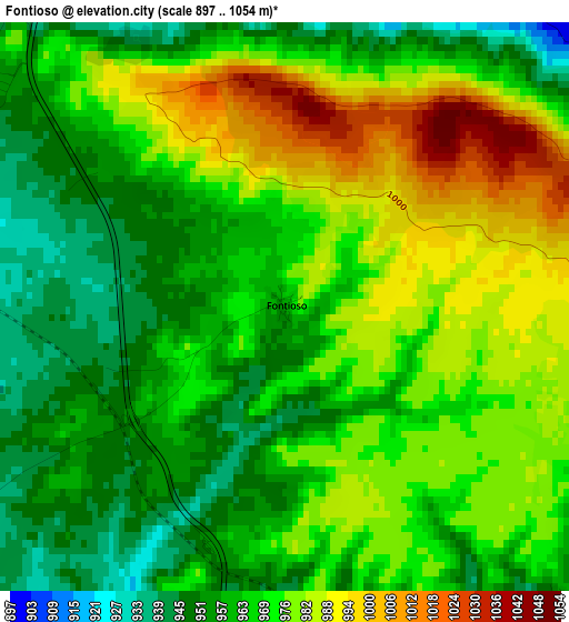
Below is the Elevation map of Fontioso, which displays elevation range with different colors. Scale of the first map is from 897 to 1054 m (2943 to 3458 ft) with average elevation of 969.6 meters (=3181 ft) [note 1]
These maps also provides idea of topography and contour of this city, they are displayed at different zoom levels. More info about maps, scale and edge coordinates you can find below images.
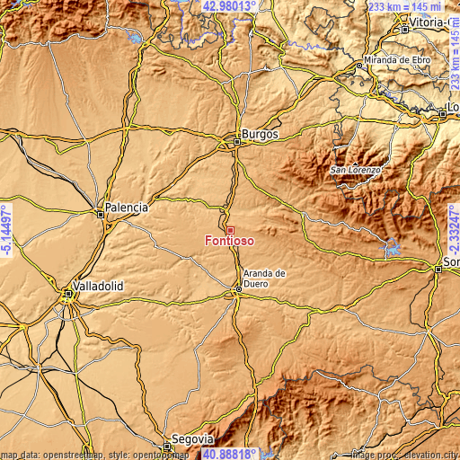
| \ | Map #1 | Topo.Map |
| Scale [m] | 897..1054 m | × |
| Scale [ft] | 2943..3458 ft | × |
| Average | 969.6 m = 3181 ft | × |
| Width | 7.27 km = 4.5 mi | 232.6 km = 144.5 mi |
| Height | 7.27 km = 4.5 mi | 232.6 km = 144.5 mi |
| ↑Max Latitude | 41.975409° | 42.98013° |
| Latitude at center | 41.94273° | 41.94273° |
| ↓Min Latitude | 41.910035° | 40.88818° |
| ← Min Longitude | -3.782665° | -5.14497° |
| Longitude center | -3.73872° | -3.73872° |
| →Max Longitude | -3.694775° | -2.33247° |
Nearby cities:
Cities around Fontioso sort by population:
• Lerma elevation 836 m
9.4 km,  349°
349°
• Villalmanzo 856 m
11.8 km,  358°
358°
• Cilleruelo de Abajo 915 m
8.1 km,  216°
216°
• Santa Inés 861 m
11.2 km,  15°
15°
• Quintanilla de la Mata 877 m
5.6 km,  334°
334°
• Avellanosa de Muñó 872 m
8.5 km,  302°
302°
• Bahabón de Esgueva 918 m
9 km,  175°
175°
• Solarana 903 m
7.4 km,  64°
64°
• Nebreda 917 m
9.1 km,  71°
71°
• Cilleruelo de Arriba 966 m
7.7 km,  123°
123°
• Cebrecos 953 m
12.6 km, 68°
• Iglesiarrubia 889 m
9.6 km,  291°
291°
Multilingual:
 En español:
Fontioso elevación 963 m.
 En France:
Fontioso élévation 963 m.
 Auf Deutsch:
Fontioso höhe über dem Meeresspiegel ist 963 m.

Sources and notes:
- [note 1] Map square and city borders are not equal. Map elevation data is calculated only from area inside that square.
- [src 1] Elevation data from geonames database provided with same terms of usage.
- [src 2] The elevation map of Fontioso is generated using elevation data from NASA's 3 arcsec (90m) resolution SRTM data.
- [src 3] Base (background) map © OpenStreetMap contributors tiles are generated by Geofabrik and OpenTopoMap.
Copyright & License:
This Fontioso Elevation Map is licensed under CC BY-SA. You may reuse any part from this page, if you give a proper credit by linking to this URL:
 More info on terms of use page.