Santa Inés elevation
Santa Inés (Castille and León, Provincia de Burgos), Spain elevation is 861 meters and Santa Inés elevation in feet is 2825 ft above sea level [src 1]. Santa Inés is a seat of a third-order administrative division (feature code) with elevation that is 258 meters (846 ft) bigger than average city elevation in Spain.
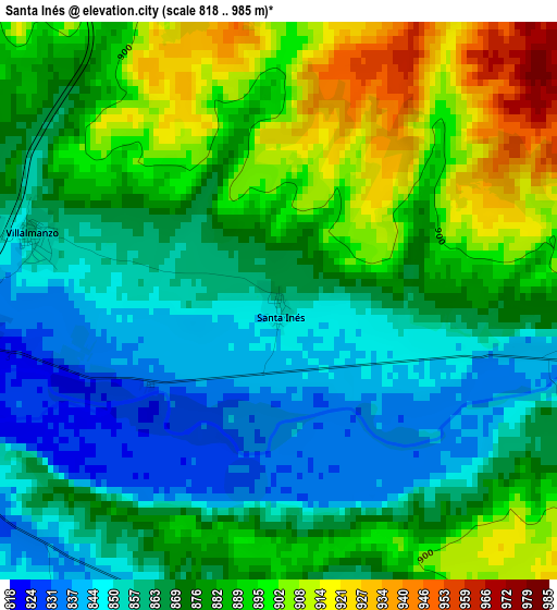
Below is the Elevation map of Santa Inés, which displays elevation range with different colors. Scale of the first map is from 818 to 985 m (2684 to 3232 ft) with average elevation of 875.1 meters (=2871 ft) [note 1]
These maps also provides idea of topography and contour of this city, they are displayed at different zoom levels. More info about maps, scale and edge coordinates you can find below images.
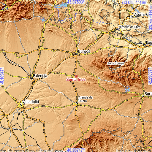
| \ | Map #1 | Topo.Map |
| Scale [m] | 818..985 m | × |
| Scale [ft] | 2684..3232 ft | × |
| Average | 875.1 m = 2871 ft | × |
| Width | 7.26 km = 4.5 mi | 232.2 km = 144.3 mi |
| Height | 7.26 km = 4.5 mi | 232.2 km = 144.3 mi |
| ↑Max Latitude | 42.072759° | 43.07593° |
| Latitude at center | 42.04013° | 42.04013° |
| ↓Min Latitude | 42.007484° | 40.98717° |
| ← Min Longitude | -3.747165° | -5.10947° |
| Longitude center | -3.70322° | -3.70322° |
| →Max Longitude | -3.659275° | -2.29697° |
Nearby cities:
Cities around Santa Inés sort by population:
• Lerma elevation 836 m
4.9 km,  251°
251°
• Villalmanzo 856 m
3.3 km,  286°
286°
• Villamayor de los Montes 888 m
8.9 km,  324°
324°
• Madrigalejo del Monte 896 m
9.5 km,  349°
349°
• Quintanilla de la Mata 877 m
7.8 km,  222°
222°
• Santa Cecilia 841 m
8.4 km,  279°
279°
• Puentedura 865 m
10 km,  89°
89°
• Solarana 903 m
8.5 km,  154°
154°
• Nebreda 917 m
9.8 km,  144°
144°
• Torrecilla del Monte 945 m
6.1 km,  7°
7°
• Fontioso 963 m
11.2 km,  195°
195°
• Cebrecos 953 m
10.8 km,  125°
125°
Multilingual:
 En español:
Santa Inés elevación 861 m.
 En France:
Santa Inés élévation 861 m.
 Auf Deutsch:
Santa Inés höhe über dem Meeresspiegel ist 861 m.

Sources and notes:
- [note 1] Map square and city borders are not equal. Map elevation data is calculated only from area inside that square.
- [src 1] Elevation data from geonames database provided with same terms of usage.
- [src 2] The elevation map of Santa Inés is generated using elevation data from NASA's 3 arcsec (90m) resolution SRTM data.
- [src 3] Base (background) map © OpenStreetMap contributors tiles are generated by Geofabrik and OpenTopoMap.
Copyright & License:
This Santa Inés Elevation Map is licensed under CC BY-SA. You may reuse any part from this page, if you give a proper credit by linking to this URL:
 More info on terms of use page.