Fraga elevation
Fraga (Aragon, Provincia de Huesca), Spain elevation is 134 meters and Fraga elevation in feet is 440 ft above sea level [src 1]. Fraga is a seat of a third-order administrative division (feature code) with elevation that is 469 meters (1539 ft) smaller than average city elevation in Spain.
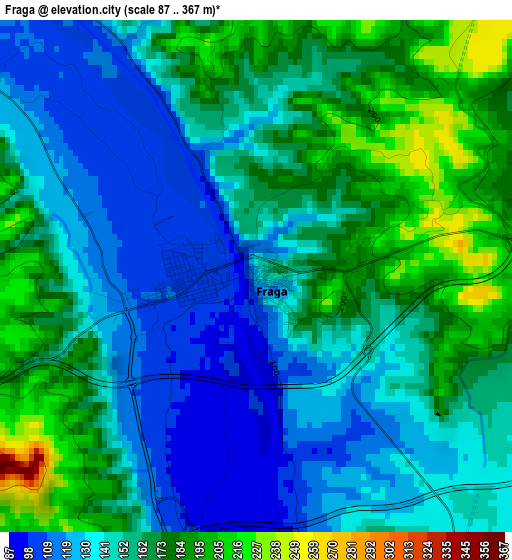
Below is the Elevation map of Fraga, which displays elevation range with different colors. Scale of the first map is from 87 to 367 m (285 to 1204 ft) with average elevation of 153.5 meters (=504 ft) [note 1]
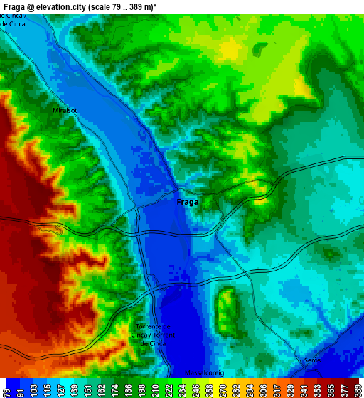
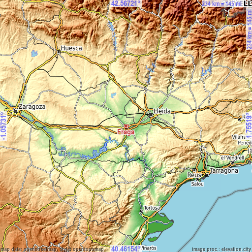
These maps also provides idea of topography and contour of this city, they are displayed at different zoom levels. More info about maps, scale and edge coordinates you can find below images.
| \ | Map #1 | Map #2 | Topo.Map |
| Scale [m] | 87..367 m | 79..389 m | × |
| Scale [ft] | 285..1204 ft | 259..1276 ft | × |
| Average | 153.5 m = 504 ft | 191.2 m = 627 ft | × |
| Width | 7.32 km = 4.5 mi | 14.63 km = 9.1 mi | 234.1 km = 145.5 mi |
| Height | 7.32 km = 4.5 mi | 14.63 km = 9.1 mi | 234.1 km = 145.5 mi |
| ↑Max Latitude | 41.555833° | 41.588709° | 42.56721° |
| Latitude at center | 41.52294° | 41.52294° | 41.52294° |
| ↓Min Latitude | 41.49003° | 41.457104° | 40.46154° |
| ← Min Longitude | 0.304995° | 0.261049° | -1.05731° |
| Longitude center | 0.34894° | 0.34894° | 0.34894° |
| →Max Longitude | 0.392885° | 0.436831° | 1.75519° |
Nearby cities:
Cities around Fraga sort by population:
• Alcarràs elevation 130 m
14.8 km,  70°
70°
• Mequinensa / Mequinenza 80 m
17.2 km,  193°
193°
• Aitona 102 m
10.7 km,  114°
114°
• Torres de Segre 126 m
13.8 km,  84°
84°
• Seròs 102 m
8.4 km,  137°
137°
• Zaidín 162 m
11.4 km,  322°
322°
• Soses 137 m
11.2 km, 84°
• Ballobar 152 m
17 km,  309°
309°
• Chalamera 180 m
22.2 km, 315°
• Maials 364 m
21.5 km, 144°
• Sunyer 174 m
20.2 km,  90°
90°
• la Granja d'Escarp 174 m
11.9 km,  172°
172°
Multilingual:
 En español:
Fraga elevación 134 m.
 En France:
Fraga élévation 134 m.


Sources and notes:
- [note 1] Map square and city borders are not equal. Map elevation data is calculated only from area inside that square.
- [src 1] Elevation data from geonames database provided with same terms of usage.
- [src 2] The elevation map of Fraga is generated using elevation data from NASA's 3 arcsec (90m) resolution SRTM data.
- [src 3] Base (background) map © OpenStreetMap contributors tiles are generated by Geofabrik and OpenTopoMap.
Copyright & License:
This Fraga Elevation Map is licensed under CC BY-SA. You may reuse any part from this page, if you give a proper credit by linking to this URL:
 More info on terms of use page.