Mequinensa / Mequinenza elevation
Mequinensa / Mequinenza (Aragon, Provincia de Zaragoza), Spain elevation is 80 meters and Mequinensa / Mequinenza elevation in feet is 262 ft above sea level [src 1]. Mequinensa / Mequinenza is a populated place (feature code) with elevation that is 523 meters (1716 ft) smaller than average city elevation in Spain.
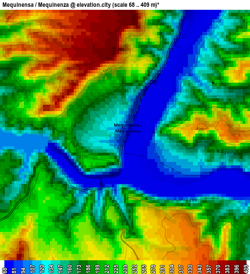
Below is the Elevation map of Mequinensa / Mequinenza, which displays elevation range with different colors. Scale of the first map is from 68 to 409 m (223 to 1342 ft) with average elevation of 202.9 meters (=666 ft) [note 1]
These maps also provides idea of topography and contour of this city, they are displayed at different zoom levels. More info about maps, scale and edge coordinates you can find below images.
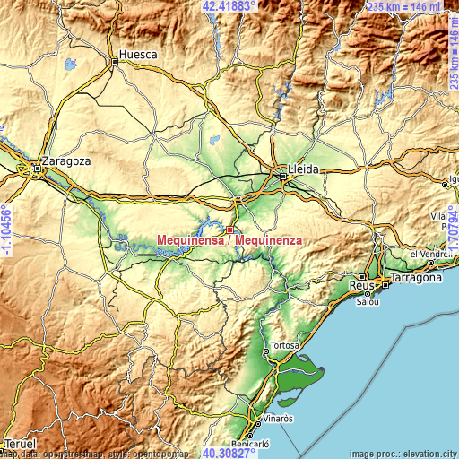
| \ | Map #1 | Topo.Map |
| Scale [m] | 68..409 m | × |
| Scale [ft] | 223..1342 ft | × |
| Average | 202.9 m = 666 ft | × |
| Width | 7.33 km = 4.6 mi | 234.7 km = 145.8 mi |
| Height | 7.33 km = 4.6 mi | 234.7 km = 145.8 mi |
| ↑Max Latitude | 41.40508° | 42.41883° |
| Latitude at center | 41.37211° | 41.37211° |
| ↓Min Latitude | 41.339124° | 40.30827° |
| ← Min Longitude | 0.257745° | -1.10456° |
| Longitude center | 0.30169° | 0.30169° |
| →Max Longitude | 0.345635° | 1.70794° |
Nearby cities:
Cities around Mequinensa / Mequinenza sort by population:
• Fraga elevation 134 m
17.2 km,  13°
13°
• Aitona 102 m
18.5 km,  48°
48°
• Torres de Segre 126 m
25.3 km,  44°
44°
• Seròs 102 m
14.2 km, 42°
• Soses 137 m
23.5 km, 40°
• Fabara 255 m
24.3 km,  207°
207°
• Nonaspe 182 m
18.7 km,  193°
193°
• Candasnos 286 m
24.5 km,  306°
306°
• Fayón 196 m
15.1 km,  170°
170°
• la Pobla de Massaluca 333 m
21.4 km, 169°
• Maials 364 m
16.6 km,  92°
92°
• la Granja d'Escarp 174 m
7.3 km, 47°
Multilingual:
 En español:
Mequinenza elevación 80 m.
 En France:
Mequinensa / Mequinenza élévation 80 m.
 Auf Deutsch:
Mequinensa / Mequinenza höhe über dem Meeresspiegel ist 80 m.
 На русском:
Mequinensa / Mequinenza высота над уровнем моря 80 м
Sources and notes:
- [note 1] Map square and city borders are not equal. Map elevation data is calculated only from area inside that square.
- [src 1] Elevation data from geonames database provided with same terms of usage.
- [src 2] The elevation map of Mequinensa / Mequinenza is generated using elevation data from NASA's 3 arcsec (90m) resolution SRTM data.
- [src 3] Base (background) map © OpenStreetMap contributors tiles are generated by Geofabrik and OpenTopoMap.
Copyright & License:
This Mequinensa / Mequinenza Elevation Map is licensed under CC BY-SA. You may reuse any part from this page, if you give a proper credit by linking to this URL:
 More info on terms of use page.