Fuente el Saz elevation
Fuente el Saz (Madrid, Provincia de Madrid), Spain elevation is 642 meters and Fuente el Saz elevation in feet is 2106 ft above sea level [src 1]. Fuente el Saz is a populated place (feature code) with elevation that is 39 meters (128 ft) bigger than average city elevation in Spain.
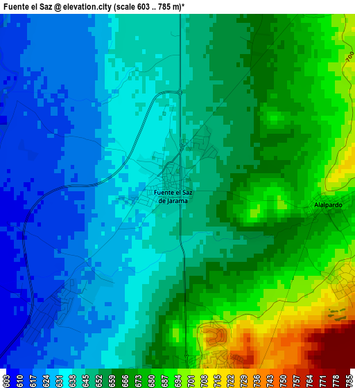
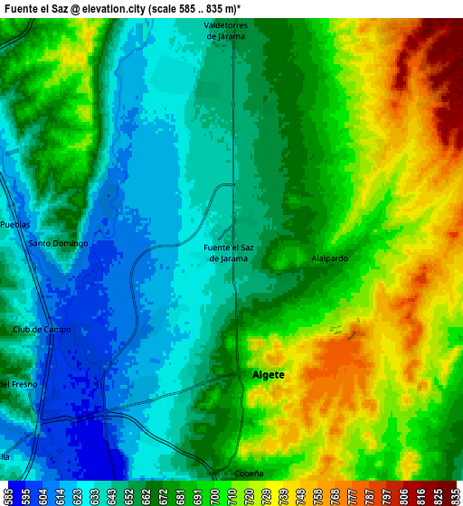
Below is the Elevation map of Fuente el Saz, which displays elevation range with different colors. Scale of the first map is from 603 to 785 m (1978 to 2575 ft) with average elevation of 652.8 meters (=2142 ft) [note 1]
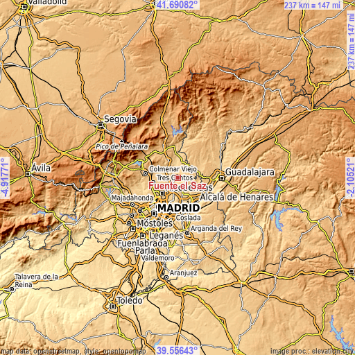
These maps also provides idea of topography and contour of this city, they are displayed at different zoom levels. More info about maps, scale and edge coordinates you can find below images.
| \ | Map #1 | Map #2 | Topo.Map |
| Scale [m] | 603..785 m | 585..835 m | × |
| Scale [ft] | 1978..2575 ft | 1919..2740 ft | × |
| Average | 652.8 m = 2142 ft | 675.1 m = 2215 ft | × |
| Width | 7.42 km = 4.6 mi | 14.83 km = 9.2 mi | 237.3 km = 147.5 mi |
| Height | 7.42 km = 4.6 mi | 14.83 km = 9.2 mi | 237.3 km = 147.5 mi |
| ↑Max Latitude | 40.665492° | 40.698817° | 41.69082° |
| Latitude at center | 40.63215° | 40.63215° | 40.63215° |
| ↓Min Latitude | 40.598791° | 40.565416° | 39.55643° |
| ← Min Longitude | -3.555405° | -3.599351° | -4.91771° |
| Longitude center | -3.51146° | -3.51146° | -3.51146° |
| →Max Longitude | -3.467515° | -3.423569° | -2.10521° |
Nearby cities:
Cities around Fuente el Saz sort by population:
• San Sebastián de los Reyes elevation 685 m
13 km,  228°
228°
• Algete 721 m
4.1 km,  163°
163°
• San Agustín del Guadalix 674 m
10.3 km,  300°
300°
• Daganzo de Arriba 662 m
11 km,  154°
154°
• El Molar 839 m
12.5 km,  332°
332°
• Cobeña 682 m
7.3 km,  172°
172°
• Valdetorres de Jarama 655 m
6.8 km,  359°
359°
• Ajalvir 666 m
11.5 km, 165°
• Valdeolmos 702 m
5.2 km,  83°
83°
• Talamanca de Jarama 655 m
12.4 km,  1°
1°
• Fresno de Torote 654 m
9.7 km,  118°
118°
• Ribatejada 744 m
10.9 km,  70°
70°
Multilingual:
 En español:
Fuente el Saz elevación 642 m.
 En France:
Fuente el Saz élévation 642 m.
 Auf Deutsch:
Fuente el Saz höhe über dem Meeresspiegel ist 642 m.

Sources and notes:
- [note 1] Map square and city borders are not equal. Map elevation data is calculated only from area inside that square.
- [src 1] Elevation data from geonames database provided with same terms of usage.
- [src 2] The elevation map of Fuente el Saz is generated using elevation data from NASA's 3 arcsec (90m) resolution SRTM data.
- [src 3] Base (background) map © OpenStreetMap contributors tiles are generated by Geofabrik and OpenTopoMap.
Copyright & License:
This Fuente el Saz Elevation Map is licensed under CC BY-SA. You may reuse any part from this page, if you give a proper credit by linking to this URL:
 More info on terms of use page.