Fuentepinilla elevation
Fuentepinilla (Castille and León, Provincia de Soria), Spain elevation is 940 meters and Fuentepinilla elevation in feet is 3084 ft above sea level [src 1]. Fuentepinilla is a seat of a third-order administrative division (feature code) with elevation that is 337 meters (1106 ft) bigger than average city elevation in Spain.
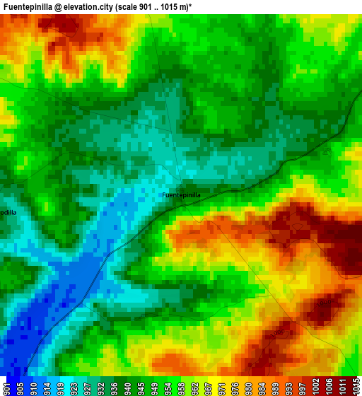
Below is the Elevation map of Fuentepinilla, which displays elevation range with different colors. Scale of the first map is from 901 to 1015 m (2956 to 3330 ft) with average elevation of 952.1 meters (=3124 ft) [note 1]
These maps also provides idea of topography and contour of this city, they are displayed at different zoom levels. More info about maps, scale and edge coordinates you can find below images.
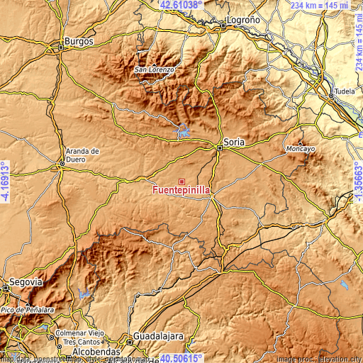
| \ | Map #1 | Topo.Map |
| Scale [m] | 901..1015 m | × |
| Scale [ft] | 2956..3330 ft | × |
| Average | 952.1 m = 3124 ft | × |
| Width | 7.31 km = 4.5 mi | 234 km = 145.4 mi |
| Height | 7.31 km = 4.5 mi | 234 km = 145.4 mi |
| ↑Max Latitude | 41.599701° | 42.61038° |
| Latitude at center | 41.56683° | 41.56683° |
| ↓Min Latitude | 41.533943° | 40.50615° |
| ← Min Longitude | -2.806825° | -4.16913° |
| Longitude center | -2.76288° | -2.76288° |
| →Max Longitude | -2.718935° | -1.35663° |
Nearby cities:
Cities around Fuentepinilla sort by population:
• Berlanga de Duero elevation 937 m
13.9 km,  216°
216°
• Tardelcuende 990 m
10.3 km,  72°
72°
• Quintana Redonda 1024 m
14.7 km,  56°
56°
• Matamala de Almazán 950 m
12.2 km,  123°
123°
• Bayubas de Abajo 927 m
11.9 km,  248°
248°
• Velamazán 980 m
14.1 km,  158°
158°
• Valderrodilla 937 m
3.8 km,  264°
264°
• Tajueco 933 m
7.9 km,  244°
244°
• Bayubas de Arriba 961 m
10.4 km, 264°
• Blacos 1000 m
15 km,  327°
327°
• Torreblacos 980 m
14.9 km,  319°
319°
• Centenera de Andaluz 945 m
7.6 km,  150°
150°
Multilingual:
 En español:
Fuentepinilla elevación 940 m.
 En France:
Fuentepinilla élévation 940 m.
 Auf Deutsch:
Fuentepinilla höhe über dem Meeresspiegel ist 940 m.

Sources and notes:
- [note 1] Map square and city borders are not equal. Map elevation data is calculated only from area inside that square.
- [src 1] Elevation data from geonames database provided with same terms of usage.
- [src 2] The elevation map of Fuentepinilla is generated using elevation data from NASA's 3 arcsec (90m) resolution SRTM data.
- [src 3] Base (background) map © OpenStreetMap contributors tiles are generated by Geofabrik and OpenTopoMap.
Copyright & License:
This Fuentepinilla Elevation Map is licensed under CC BY-SA. You may reuse any part from this page, if you give a proper credit by linking to this URL:
 More info on terms of use page.