Hormigos elevation
Hormigos (Castille-La Mancha, Province of Toledo), Spain elevation is 463 meters and Hormigos elevation in feet is 1519 ft above sea level [src 1]. Hormigos is a seat of a third-order administrative division (feature code) with elevation that is 140 meters (459 ft) smaller than average city elevation in Spain.
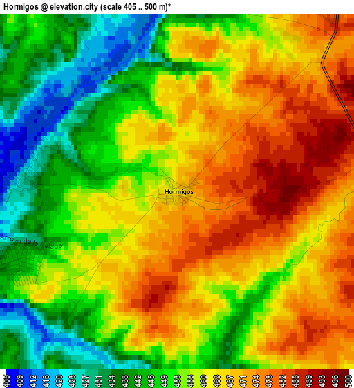
Below is the Elevation map of Hormigos, which displays elevation range with different colors. Scale of the first map is from 405 to 500 m (1329 to 1640 ft) with average elevation of 457.9 meters (=1502 ft) [note 1]
These maps also provides idea of topography and contour of this city, they are displayed at different zoom levels. More info about maps, scale and edge coordinates you can find below images.
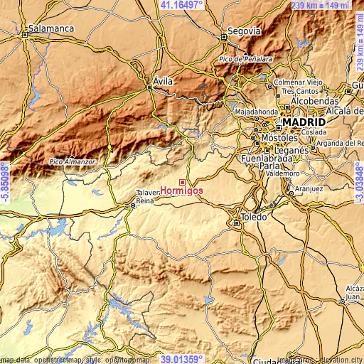
| \ | Map #1 | Topo.Map |
| Scale [m] | 405..500 m | × |
| Scale [ft] | 1329..1640 ft | × |
| Average | 457.9 m = 1502 ft | × |
| Width | 7.48 km = 4.6 mi | 239.2 km = 148.6 mi |
| Height | 7.48 km = 4.6 mi | 239.2 km = 148.6 mi |
| ↑Max Latitude | 40.131388° | 41.16497° |
| Latitude at center | 40.09778° | 40.09778° |
| ↓Min Latitude | 40.064156° | 39.01359° |
| ← Min Longitude | -4.488675° | -5.85098° |
| Longitude center | -4.44473° | -4.44473° |
| →Max Longitude | -4.400785° | -3.03848° |
Nearby cities:
Cities around Hormigos sort by population:
• Santa Olalla elevation 486 m
8.4 km,  171°
171°
• Escalona 464 m
8.4 km,  23°
23°
• Quismondo 549 m
10.3 km,  85°
85°
• El Casar de Escalona 466 m
8.9 km,  230°
230°
• Nombela 484 m
8 km,  322°
322°
• Alcabón 531 m
12.4 km,  148°
148°
• Maqueda 484 m
7.2 km,  119°
119°
• Domingo Pérez 498 m
14.4 km,  201°
201°
• Carriches 551 m
14.9 km,  184°
184°
• Otero 465 m
12.3 km,  209°
209°
• Nuño Gómez 472 m
15 km,  276°
276°
• Paredes de Escalona 498 m
12 km,  5°
5°
Multilingual:
 En español:
Hormigos elevación 463 m.
 En France:
Hormigos élévation 463 m.
 Auf Deutsch:
Hormigos höhe über dem Meeresspiegel ist 463 m.

Sources and notes:
- [note 1] Map square and city borders are not equal. Map elevation data is calculated only from area inside that square.
- [src 1] Elevation data from geonames database provided with same terms of usage.
- [src 2] The elevation map of Hormigos is generated using elevation data from NASA's 3 arcsec (90m) resolution SRTM data.
- [src 3] Base (background) map © OpenStreetMap contributors tiles are generated by Geofabrik and OpenTopoMap.
Copyright & License:
This Hormigos Elevation Map is licensed under CC BY-SA. You may reuse any part from this page, if you give a proper credit by linking to this URL:
 More info on terms of use page.