Huérmeces elevation
Huérmeces (Castille and León, Provincia de Burgos), Spain elevation is 890 meters and Huérmeces elevation in feet is 2920 ft above sea level [src 1]. Huérmeces is a seat of a third-order administrative division (feature code) with elevation that is 287 meters (942 ft) bigger than average city elevation in Spain.
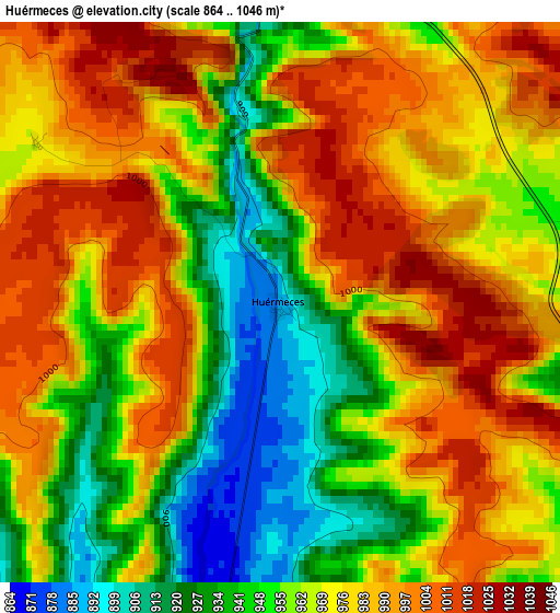
Below is the Elevation map of Huérmeces, which displays elevation range with different colors. Scale of the first map is from 864 to 1046 m (2835 to 3432 ft) with average elevation of 968.1 meters (=3176 ft) [note 1]
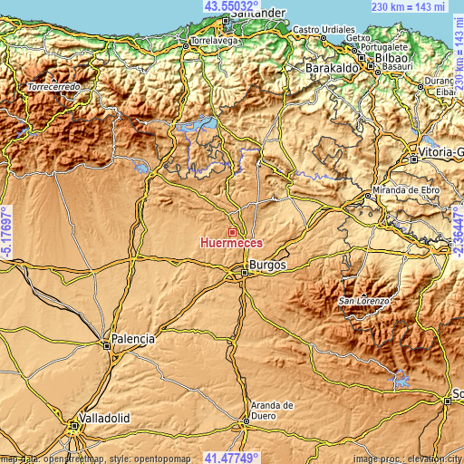
These maps also provides idea of topography and contour of this city, they are displayed at different zoom levels. More info about maps, scale and edge coordinates you can find below images.
| \ | Map #1 | Topo.Map |
| Scale [m] | 864..1046 m | × |
| Scale [ft] | 2835..3432 ft | × |
| Average | 968.1 m = 3176 ft | × |
| Width | 7.2 km = 4.5 mi | 230.5 km = 143.2 mi |
| Height | 7.2 km = 4.5 mi | 230.5 km = 143.2 mi |
| ↑Max Latitude | 42.55488° | 43.55032° |
| Latitude at center | 42.5225° | 42.5225° |
| ↓Min Latitude | 42.490103° | 41.47749° |
| ← Min Longitude | -3.814665° | -5.17697° |
| Longitude center | -3.77072° | -3.77072° |
| →Max Longitude | -3.726775° | -2.36447° |
Nearby cities:
Cities around Huérmeces sort by population:
• Villadiego elevation 841 m
19.6 km,  267°
267°
• Villalbilla de Burgos 834 m
19.5 km,  182°
182°
• Tardajos 827 m
19.7 km,  191°
191°
• Sotragero 849 m
13.4 km,  159°
159°
• Montorio 950 m
6.9 km,  355°
355°
• Quintanaortuño 866 m
10.8 km,  138°
138°
• Susinos del Páramo 891 m
13.9 km,  245°
245°
• Pedrosa del Páramo 941 m
18.8 km,  241°
241°
• Hurones 923 m
18.2 km, 135°
• Tobar 879 m
14.5 km, 252°
• Abajas 837 m
19.2 km,  54°
54°
• Manciles 894 m
16 km, 243°
Multilingual:
 En español:
Huérmeces elevación 890 m.
 En France:
Huérmeces élévation 890 m.
 Auf Deutsch:
Huérmeces höhe über dem Meeresspiegel ist 890 m.

Sources and notes:
- [note 1] Map square and city borders are not equal. Map elevation data is calculated only from area inside that square.
- [src 1] Elevation data from geonames database provided with same terms of usage.
- [src 2] The elevation map of Huérmeces is generated using elevation data from NASA's 3 arcsec (90m) resolution SRTM data.
- [src 3] Base (background) map © OpenStreetMap contributors tiles are generated by Geofabrik and OpenTopoMap.
Copyright & License:
This Huérmeces Elevation Map is licensed under CC BY-SA. You may reuse any part from this page, if you give a proper credit by linking to this URL:
 More info on terms of use page.