Ivorra elevation
Ivorra (Catalonia, Província de Lleida), Spain elevation is 548 meters and Ivorra elevation in feet is 1798 ft above sea level [src 1]. Ivorra is a seat of a third-order administrative division (feature code) with elevation that is 55 meters (180 ft) smaller than average city elevation in Spain.
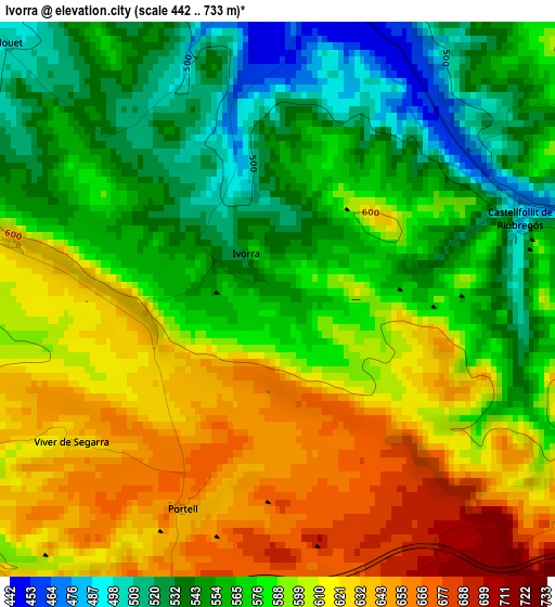
Below is the Elevation map of Ivorra, which displays elevation range with different colors. Scale of the first map is from 442 to 733 m (1450 to 2405 ft) with average elevation of 585.3 meters (=1920 ft) [note 1]
These maps also provides idea of topography and contour of this city, they are displayed at different zoom levels. More info about maps, scale and edge coordinates you can find below images.
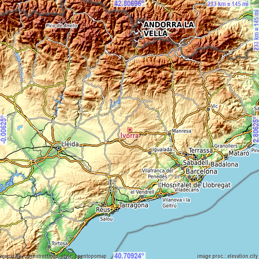
| \ | Map #1 | Topo.Map |
| Scale [m] | 442..733 m | × |
| Scale [ft] | 1450..2405 ft | × |
| Average | 585.3 m = 1920 ft | × |
| Width | 7.29 km = 4.5 mi | 233.2 km = 144.9 mi |
| Height | 7.29 km = 4.5 mi | 233.2 km = 144.9 mi |
| ↑Max Latitude | 41.799439° | 42.80696° |
| Latitude at center | 41.76667° | 41.76667° |
| ↓Min Latitude | 41.733884° | 40.70924° |
| ← Min Longitude | 1.356055° | -0.00625° |
| Longitude center | 1.4° | 1.4° |
| →Max Longitude | 1.443945° | 2.80625° |
Nearby cities:
Cities around Ivorra sort by population:
• Cervera elevation 550 m
15.1 km,  224°
224°
• Calaf 680 m
10.2 km,  111°
111°
• Ponts 364 m
24.3 km,  313°
313°
• Torà de Riubregós 518 m
5.6 km,  0°
0°
• Fonollosa 529 m
22.3 km,  91°
91°
• Jorba 401 m
22 km,  146°
146°
• Aguilar de Segarra 542 m
19.1 km,  96°
96°
• Ossó de Sió 392 m
20 km,  266°
266°
• Pujalt 760 m
5.8 km,  162°
162°
• Argensola 653 m
19.1 km,  168°
168°
• Sant Guim de Freixenet 742 m
12.4 km, 172°
• Castellfollit de Riubregós 548 m
2.8 km, 90°
Multilingual:
 En español:
Iborra elevación 548 m.
 En France:
Ivorra élévation 548 m.


Sources and notes:
- [note 1] Map square and city borders are not equal. Map elevation data is calculated only from area inside that square.
- [src 1] Elevation data from geonames database provided with same terms of usage.
- [src 2] The elevation map of Ivorra is generated using elevation data from NASA's 3 arcsec (90m) resolution SRTM data.
- [src 3] Base (background) map © OpenStreetMap contributors tiles are generated by Geofabrik and OpenTopoMap.
Copyright & License:
This Ivorra Elevation Map is licensed under CC BY-SA. You may reuse any part from this page, if you give a proper credit by linking to this URL:
 More info on terms of use page.