Ponts elevation
Ponts (Catalonia, Província de Lleida), Spain elevation is 364 meters and Ponts elevation in feet is 1194 ft above sea level [src 1]. Ponts is a populated place (feature code) with elevation that is 239 meters (784 ft) smaller than average city elevation in Spain.
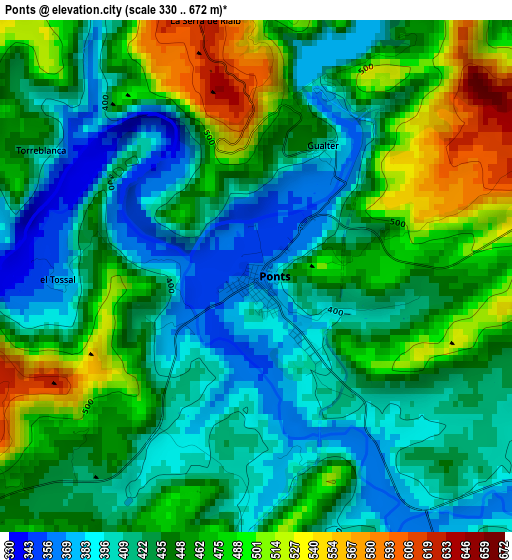
Below is the Elevation map of Ponts, which displays elevation range with different colors. Scale of the first map is from 330 to 672 m (1083 to 2205 ft) with average elevation of 442.4 meters (=1451 ft) [note 1]
These maps also provides idea of topography and contour of this city, they are displayed at different zoom levels. More info about maps, scale and edge coordinates you can find below images.
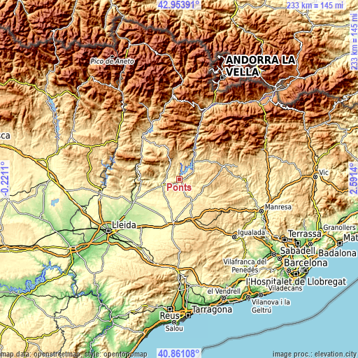
| \ | Map #1 | Topo.Map |
| Scale [m] | 330..672 m | × |
| Scale [ft] | 1083..2205 ft | × |
| Average | 442.4 m = 1451 ft | × |
| Width | 7.27 km = 4.5 mi | 232.7 km = 144.6 mi |
| Height | 7.27 km = 4.5 mi | 232.7 km = 144.6 mi |
| ↑Max Latitude | 41.948762° | 42.95391° |
| Latitude at center | 41.91607° | 41.91607° |
| ↓Min Latitude | 41.883361° | 40.86108° |
| ← Min Longitude | 1.141205° | -0.2211° |
| Longitude center | 1.18515° | 1.18515° |
| →Max Longitude | 1.229095° | 2.5914° |
Nearby cities:
Cities around Ponts sort by population:
• Agramunt elevation 342 m
16.1 km,  206°
206°
• Artesa de Segre 333 m
11.7 km,  258°
258°
• Oliana 460 m
20 km,  31°
31°
• Torà de Riubregós 518 m
20.9 km,  121°
121°
• Castellserà 284 m
24 km,  219°
219°
• Camarasa 294 m
25.8 km, 259°
• Tornabous 297 m
26.3 km,  204°
204°
• Cubells 493 m
20.1 km,  248°
248°
• Ossó de Sió 392 m
18.1 km,  186°
186°
• Tiurana 645 m
8.8 km,  41°
41°
• Penelles 262 m
25.9 km, 224°
• Ivorra 548 m
24.3 km,  133°
133°
Multilingual:
 En español:
Ponts elevación 364 m.
 En France:
Ponts élévation 364 m.


Sources and notes:
- [note 1] Map square and city borders are not equal. Map elevation data is calculated only from area inside that square.
- [src 1] Elevation data from geonames database provided with same terms of usage.
- [src 2] The elevation map of Ponts is generated using elevation data from NASA's 3 arcsec (90m) resolution SRTM data.
- [src 3] Base (background) map © OpenStreetMap contributors tiles are generated by Geofabrik and OpenTopoMap.
Copyright & License:
This Ponts Elevation Map is licensed under CC BY-SA. You may reuse any part from this page, if you give a proper credit by linking to this URL:
 More info on terms of use page.