Justel elevation
Justel (Castille and León, Provincia de Zamora), Spain elevation is 985 meters and Justel elevation in feet is 3232 ft above sea level [src 1]. Justel is a seat of a third-order administrative division (feature code) with elevation that is 382 meters (1253 ft) bigger than average city elevation in Spain.
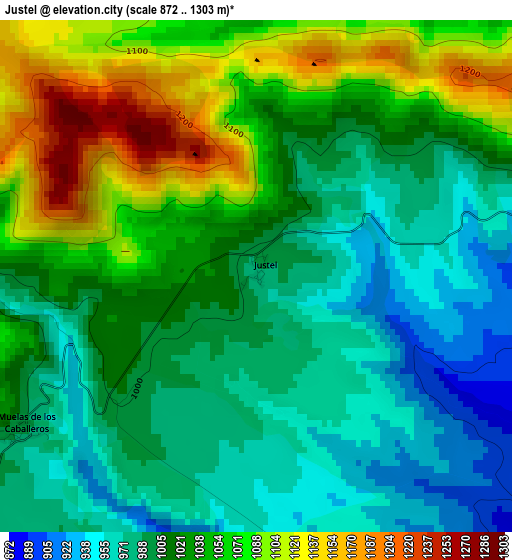
Below is the Elevation map of Justel, which displays elevation range with different colors. Scale of the first map is from 872 to 1303 m (2861 to 4275 ft) with average elevation of 1023 meters (=3356 ft) [note 1]
These maps also provides idea of topography and contour of this city, they are displayed at different zoom levels. More info about maps, scale and edge coordinates you can find below images.
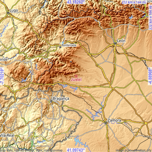
| \ | Map #1 | Topo.Map |
| Scale [m] | 872..1303 m | × |
| Scale [ft] | 2861..4275 ft | × |
| Average | 1023 m = 3356 ft | × |
| Width | 7.25 km = 4.5 mi | 231.9 km = 144.1 mi |
| Height | 7.25 km = 4.5 mi | 231.8 km = 144 mi |
| ↑Max Latitude | 42.181183° | 43.18262° |
| Latitude at center | 42.14861° | 42.14861° |
| ↓Min Latitude | 42.11602° | 41.09743° |
| ← Min Longitude | -6.339885° | -7.70219° |
| Longitude center | -6.29594° | -6.29594° |
| →Max Longitude | -6.251995° | -4.88969° |
Nearby cities:
Cities around Justel sort by population:
• Castrocontrigo elevation 917 m
9.5 km,  65°
65°
• Truchas 1121 m
17 km,  317°
317°
• Ayoó de Vidriales 808 m
19.1 km,  96°
96°
• Mombuey 891 m
14.3 km,  191°
191°
• Muelas de los Caballeros 997 m
4.1 km,  236°
236°
• Uña de Quintana 783 m
14.2 km,  118°
118°
• Espadañedo 1031 m
8.9 km,  246°
246°
• Manzanal de los Infantes 920 m
12.7 km,  214°
214°
• Cernadilla 907 m
17.4 km,  215°
215°
• Peque 853 m
8.6 km,  168°
168°
• Cubo de Benavente 813 m
11.2 km, 103°
• Molezuelas de la Carballeda 804 m
11.7 km,  129°
129°
Multilingual:
 En español:
Justel elevación 985 m.
 En France:
Justel élévation 985 m.


Sources and notes:
- [note 1] Map square and city borders are not equal. Map elevation data is calculated only from area inside that square.
- [src 1] Elevation data from geonames database provided with same terms of usage.
- [src 2] The elevation map of Justel is generated using elevation data from NASA's 3 arcsec (90m) resolution SRTM data.
- [src 3] Base (background) map © OpenStreetMap contributors tiles are generated by Geofabrik and OpenTopoMap.
Copyright & License:
This Justel Elevation Map is licensed under CC BY-SA. You may reuse any part from this page, if you give a proper credit by linking to this URL:
 More info on terms of use page.