Uña de Quintana elevation
Uña de Quintana (Castille and León, Provincia de Zamora), Spain elevation is 783 meters and Uña de Quintana elevation in feet is 2569 ft above sea level [src 1]. Uña de Quintana is a seat of a third-order administrative division (feature code) with elevation that is 180 meters (591 ft) bigger than average city elevation in Spain.
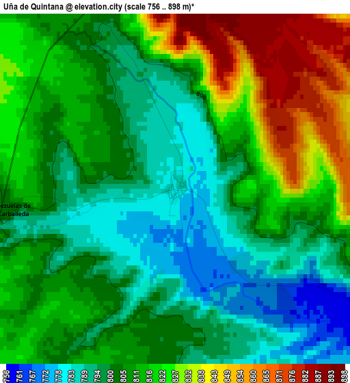
Below is the Elevation map of Uña de Quintana, which displays elevation range with different colors. Scale of the first map is from 756 to 898 m (2480 to 2946 ft) with average elevation of 809.9 meters (=2657 ft) [note 1]
These maps also provides idea of topography and contour of this city, they are displayed at different zoom levels. More info about maps, scale and edge coordinates you can find below images.
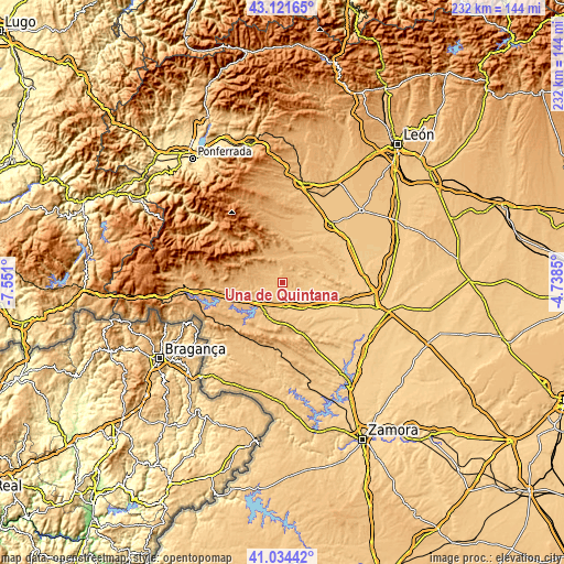
| \ | Map #1 | Topo.Map |
| Scale [m] | 756..898 m | × |
| Scale [ft] | 2480..2946 ft | × |
| Average | 809.9 m = 2657 ft | × |
| Width | 7.25 km = 4.5 mi | 232.1 km = 144.2 mi |
| Height | 7.25 km = 4.5 mi | 232.1 km = 144.2 mi |
| ↑Max Latitude | 42.119225° | 43.12165° |
| Latitude at center | 42.08662° | 42.08662° |
| ↓Min Latitude | 42.053998° | 41.03442° |
| ← Min Longitude | -6.188695° | -7.551° |
| Longitude center | -6.14475° | -6.14475° |
| →Max Longitude | -6.100805° | -4.7385° |
Nearby cities:
Cities around Uña de Quintana sort by population:
• Santibáñez de Vidriales elevation 745 m
10.8 km,  97°
97°
• Castrocontrigo 917 m
11.4 km,  340°
340°
• Camarzana de Tera 735 m
14.1 km,  136°
136°
• San Pedro de Ceque 760 m
7.7 km,  128°
128°
• Calzadilla de Tera 757 m
13 km,  156°
156°
• Vega de Tera 759 m
10 km,  170°
170°
• Ayoó de Vidriales 808 m
8.2 km,  53°
53°
• Brime de Sog 764 m
8.5 km,  109°
109°
• Peque 853 m
10.8 km,  261°
261°
• Cubo de Benavente 813 m
4.5 km, 340°
• Fuente Encalada 752 m
12.5 km,  77°
77°
• Molezuelas de la Carballeda 804 m
3.5 km, 261°
Multilingual:
 En español:
Uña de Quintana elevación 783 m.
 En France:
Uña de Quintana élévation 783 m.
 Auf Deutsch:
Uña de Quintana höhe über dem Meeresspiegel ist 783 m.

Sources and notes:
- [note 1] Map square and city borders are not equal. Map elevation data is calculated only from area inside that square.
- [src 1] Elevation data from geonames database provided with same terms of usage.
- [src 2] The elevation map of Uña de Quintana is generated using elevation data from NASA's 3 arcsec (90m) resolution SRTM data.
- [src 3] Base (background) map © OpenStreetMap contributors tiles are generated by Geofabrik and OpenTopoMap.
Copyright & License:
This Uña de Quintana Elevation Map is licensed under CC BY-SA. You may reuse any part from this page, if you give a proper credit by linking to this URL:
 More info on terms of use page.