Lagartos elevation
Lagartos (Castille and León, Provincia de Palencia), Spain elevation is 916 meters and Lagartos elevation in feet is 3005 ft above sea level [src 1]. Lagartos is a seat of a third-order administrative division (feature code) with elevation that is 313 meters (1027 ft) bigger than average city elevation in Spain.
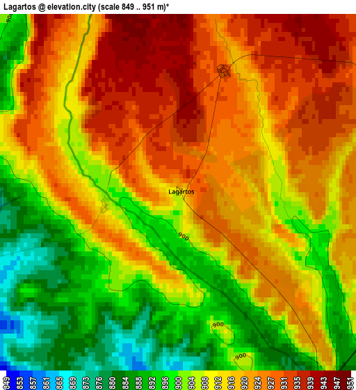
Below is the Elevation map of Lagartos, which displays elevation range with different colors. Scale of the first map is from 849 to 951 m (2785 to 3120 ft) with average elevation of 912.4 meters (=2993 ft) [note 1]
These maps also provides idea of topography and contour of this city, they are displayed at different zoom levels. More info about maps, scale and edge coordinates you can find below images.
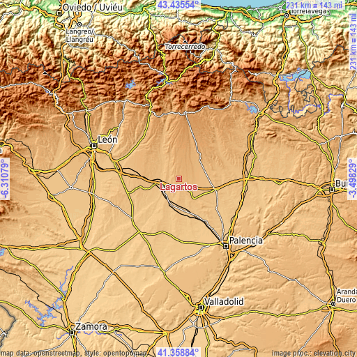
| \ | Map #1 | Topo.Map |
| Scale [m] | 849..951 m | × |
| Scale [ft] | 2785..3120 ft | × |
| Average | 912.4 m = 2993 ft | × |
| Width | 7.22 km = 4.5 mi | 230.9 km = 143.5 mi |
| Height | 7.22 km = 4.5 mi | 230.9 km = 143.5 mi |
| ↑Max Latitude | 42.43822° | 43.43554° |
| Latitude at center | 42.40578° | 42.40578° |
| ↓Min Latitude | 42.373323° | 41.35884° |
| ← Min Longitude | -4.948485° | -6.31079° |
| Longitude center | -4.90454° | -4.90454° |
| →Max Longitude | -4.860595° | -3.49829° |
Nearby cities:
Cities around Lagartos sort by population:
• Sahagún elevation 828 m
11 km,  249°
249°
• Santervás de la Vega 924 m
14.1 km,  37°
37°
• Bustillo de la Vega 885 m
14.5 km,  67°
67°
• Calzada del Coto 823 m
14.4 km,  261°
261°
• Grajal de Campos 805 m
13.4 km,  224°
224°
• Villarrabé 903 m
10 km,  80°
80°
• Villamol 822 m
12.1 km,  281°
281°
• Ledigos 877 m
6.5 km,  150°
150°
• Población de Arroyo 856 m
8.1 km,  161°
161°
• Villalcón 824 m
13.2 km, 162°
• Moratinos 860 m
5.3 km,  201°
201°
• Escobar de Campos 818 m
11.4 km,  206°
206°
Multilingual:
 En español:
Lagartos elevación 916 m.
 En France:
Lagartos élévation 916 m.
 Auf Deutsch:
Lagartos höhe über dem Meeresspiegel ist 916 m.

Sources and notes:
- [note 1] Map square and city borders are not equal. Map elevation data is calculated only from area inside that square.
- [src 1] Elevation data from geonames database provided with same terms of usage.
- [src 2] The elevation map of Lagartos is generated using elevation data from NASA's 3 arcsec (90m) resolution SRTM data.
- [src 3] Base (background) map © OpenStreetMap contributors tiles are generated by Geofabrik and OpenTopoMap.
Copyright & License:
This Lagartos Elevation Map is licensed under CC BY-SA. You may reuse any part from this page, if you give a proper credit by linking to this URL:
 More info on terms of use page.