Langa de Duero elevation
Langa de Duero (Castille and León, Provincia de Soria), Spain elevation is 844 meters and Langa de Duero elevation in feet is 2769 ft above sea level [src 1]. Langa de Duero is a seat of a third-order administrative division (feature code) with elevation that is 241 meters (791 ft) bigger than average city elevation in Spain.
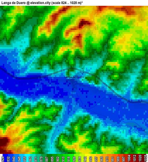
Below is the Elevation map of Langa de Duero, which displays elevation range with different colors. Scale of the first map is from 824 to 1028 m (2703 to 3373 ft) with average elevation of 892 meters (=2927 ft) [note 1]
These maps also provides idea of topography and contour of this city, they are displayed at different zoom levels. More info about maps, scale and edge coordinates you can find below images.
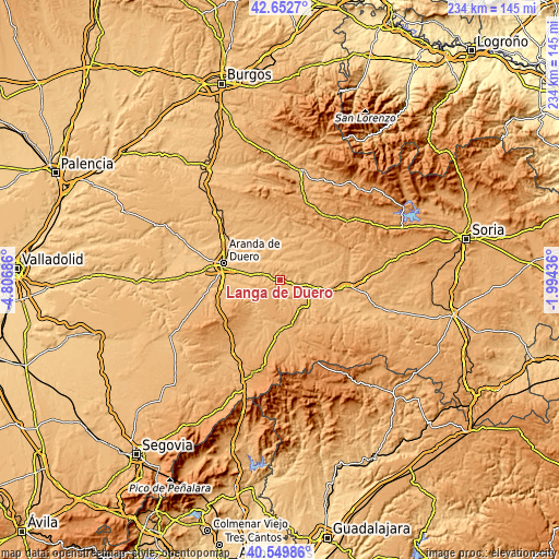
| \ | Map #1 | Topo.Map |
| Scale [m] | 824..1028 m | × |
| Scale [ft] | 2703..3373 ft | × |
| Average | 892 m = 2927 ft | × |
| Width | 7.31 km = 4.5 mi | 233.8 km = 145.3 mi |
| Height | 7.31 km = 4.5 mi | 233.8 km = 145.3 mi |
| ↑Max Latitude | 41.642699° | 42.6527° |
| Latitude at center | 41.60985° | 41.60985° |
| ↓Min Latitude | 41.576984° | 40.54986° |
| ← Min Longitude | -3.444555° | -4.80686° |
| Longitude center | -3.40061° | -3.40061° |
| →Max Longitude | -3.356665° | -1.99436° |
Nearby cities:
Cities around Langa de Duero sort by population:
• San Esteban de Gormaz elevation 860 m
16.8 km,  103°
103°
• Peñaranda de Duero 858 m
10.9 km,  323°
323°
• Vadocondes 810 m
14.8 km,  282°
282°
• Zazuar 832 m
15.9 km,  306°
306°
• Alcubilla de Avellaneda 930 m
15.2 km,  31°
31°
• Arandilla 883 m
14.4 km,  350°
350°
• Santa Cruz de la Salceda 899 m
16.1 km,  264°
264°
• San Juan del Monte 844 m
13.1 km, 308°
• Castillejo de Robledo 960 m
9.8 km,  234°
234°
• Brazacorta 912 m
12.3 km,  13°
13°
• Miño de San Esteban 941 m
9.4 km,  151°
151°
• Fuentecambrón 1015 m
13 km, 152°
Multilingual:
 En español:
Langa de Duero elevación 844 m.
 En France:
Langa de Duero élévation 844 m.
 Auf Deutsch:
Langa de Duero höhe über dem Meeresspiegel ist 844 m.

Sources and notes:
- [note 1] Map square and city borders are not equal. Map elevation data is calculated only from area inside that square.
- [src 1] Elevation data from geonames database provided with same terms of usage.
- [src 2] The elevation map of Langa de Duero is generated using elevation data from NASA's 3 arcsec (90m) resolution SRTM data.
- [src 3] Base (background) map © OpenStreetMap contributors tiles are generated by Geofabrik and OpenTopoMap.
Copyright & License:
This Langa de Duero Elevation Map is licensed under CC BY-SA. You may reuse any part from this page, if you give a proper credit by linking to this URL:
 More info on terms of use page.