Lécera elevation
Lécera (Aragon, Provincia de Zaragoza), Spain elevation is 534 meters and Lécera elevation in feet is 1752 ft above sea level [src 1]. Lécera is a seat of a third-order administrative division (feature code) with elevation that is 69 meters (226 ft) smaller than average city elevation in Spain.
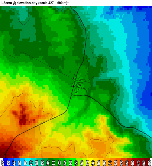
Below is the Elevation map of Lécera, which displays elevation range with different colors. Scale of the first map is from 427 to 690 m (1401 to 2264 ft) with average elevation of 531.6 meters (=1744 ft) [note 1]
These maps also provides idea of topography and contour of this city, they are displayed at different zoom levels. More info about maps, scale and edge coordinates you can find below images.
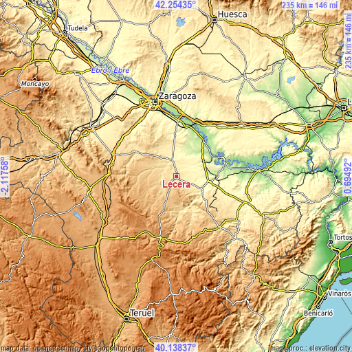
| \ | Map #1 | Topo.Map |
| Scale [m] | 427..690 m | × |
| Scale [ft] | 1401..2264 ft | × |
| Average | 531.6 m = 1744 ft | × |
| Width | 7.35 km = 4.6 mi | 235.3 km = 146.2 mi |
| Height | 7.35 km = 4.6 mi | 235.3 km = 146.2 mi |
| ↑Max Latitude | 41.237964° | 42.25435° |
| Latitude at center | 41.20491° | 41.20491° |
| ↓Min Latitude | 41.171839° | 40.13837° |
| ← Min Longitude | -0.755275° | -2.11758° |
| Longitude center | -0.71133° | -0.71133° |
| →Max Longitude | -0.667385° | 0.69492° |
Nearby cities:
Cities around Lécera sort by population:
• Albalate del Arzobispo elevation 355 m
19.1 km,  118°
118°
• Belchite 415 m
11.8 km,  342°
342°
• Muniesa 789 m
20.9 km,  203°
203°
• Azuara 582 m
14.6 km,  293°
293°
• Alacón 636 m
20 km,  176°
176°
• Letux 518 m
9.5 km,  306°
306°
• Moyuela 741 m
19.6 km,  244°
244°
• Almonacid de la Cuba 491 m
10.8 km,  321°
321°
• Samper del Salz 539 m
10.1 km, 289°
• Lagata 527 m
8.7 km,  296°
296°
• Moneva 657 m
13.5 km,  230°
230°
• Almochuel 278 m
15.8 km,  58°
58°
Multilingual:
 En español:
Lécera elevación 534 m.
 En France:
Lécera élévation 534 m.


Sources and notes:
- [note 1] Map square and city borders are not equal. Map elevation data is calculated only from area inside that square.
- [src 1] Elevation data from geonames database provided with same terms of usage.
- [src 2] The elevation map of Lécera is generated using elevation data from NASA's 3 arcsec (90m) resolution SRTM data.
- [src 3] Base (background) map © OpenStreetMap contributors tiles are generated by Geofabrik and OpenTopoMap.
Copyright & License:
This Lécera Elevation Map is licensed under CC BY-SA. You may reuse any part from this page, if you give a proper credit by linking to this URL:
 More info on terms of use page.