Moneva elevation
Moneva (Aragon, Provincia de Zaragoza), Spain elevation is 657 meters and Moneva elevation in feet is 2156 ft above sea level [src 1]. Moneva is a seat of a third-order administrative division (feature code) with elevation that is 54 meters (177 ft) bigger than average city elevation in Spain.
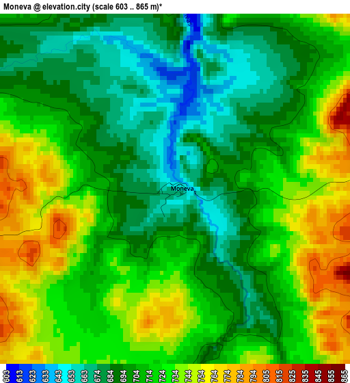
Below is the Elevation map of Moneva, which displays elevation range with different colors. Scale of the first map is from 603 to 865 m (1978 to 2838 ft) with average elevation of 712 meters (=2336 ft) [note 1]
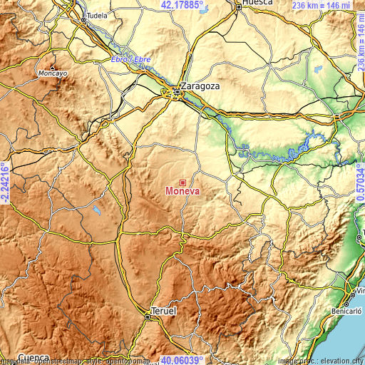
These maps also provides idea of topography and contour of this city, they are displayed at different zoom levels. More info about maps, scale and edge coordinates you can find below images.
| \ | Map #1 | Topo.Map |
| Scale [m] | 603..865 m | × |
| Scale [ft] | 1978..2838 ft | × |
| Average | 712 m = 2336 ft | × |
| Width | 7.36 km = 4.6 mi | 235.6 km = 146.4 mi |
| Height | 7.36 km = 4.6 mi | 235.5 km = 146.3 mi |
| ↑Max Latitude | 41.161263° | 42.17885° |
| Latitude at center | 41.12817° | 41.12817° |
| ↓Min Latitude | 41.09506° | 40.06039° |
| ← Min Longitude | -0.879855° | -2.24216° |
| Longitude center | -0.83591° | -0.83591° |
| →Max Longitude | -0.791965° | 0.57034° |
Nearby cities:
Cities around Moneva sort by population:
• Lécera elevation 534 m
13.5 km,  50°
50°
• Muniesa 789 m
10.8 km,  169°
169°
• Azuara 582 m
14.8 km,  348°
348°
• Alacón 636 m
16.2 km,  134°
134°
• Letux 518 m
14.4 km,  11°
11°
• Moyuela 741 m
7.2 km,  269°
269°
• Blesa 778 m
9.5 km,  205°
205°
• Plenas 824 m
10.9 km,  260°
260°
• Samper del Salz 539 m
11.9 km,  4°
4°
• Lagata 527 m
12.7 km, 11°
• Huesa del Común 858 m
14.8 km, 207°
• Plou 907 m
15.1 km,  185°
185°
Multilingual:
 En español:
Moneva elevación 657 m.
 En France:
Moneva élévation 657 m.


Sources and notes:
- [note 1] Map square and city borders are not equal. Map elevation data is calculated only from area inside that square.
- [src 1] Elevation data from geonames database provided with same terms of usage.
- [src 2] The elevation map of Moneva is generated using elevation data from NASA's 3 arcsec (90m) resolution SRTM data.
- [src 3] Base (background) map © OpenStreetMap contributors tiles are generated by Geofabrik and OpenTopoMap.
Copyright & License:
This Moneva Elevation Map is licensed under CC BY-SA. You may reuse any part from this page, if you give a proper credit by linking to this URL:
 More info on terms of use page.