Leganés elevation
Leganés (Madrid, Provincia de Madrid), Spain elevation is 672 meters and Leganés elevation in feet is 2205 ft above sea level [src 1]. Leganés is a seat of a third-order administrative division (feature code) with elevation that is 69 meters (226 ft) bigger than average city elevation in Spain.
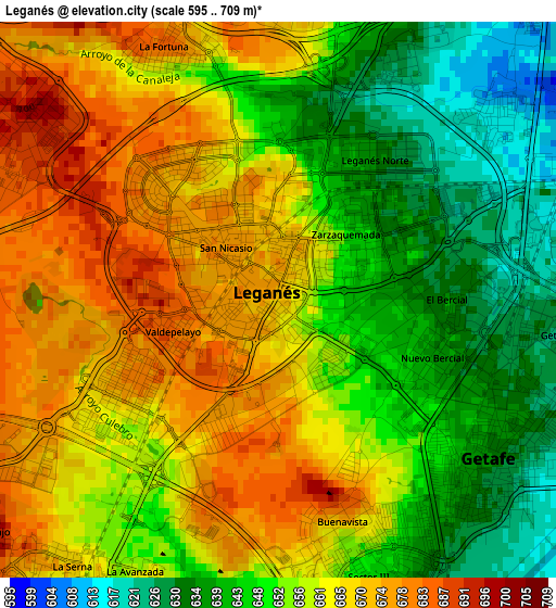
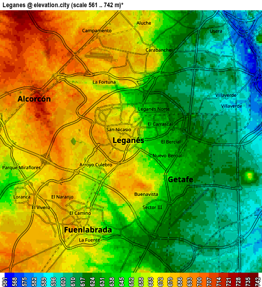
Below is the Elevation map of Leganés, which displays elevation range with different colors. Scale of the first map is from 595 to 709 m (1952 to 2326 ft) with average elevation of 656.9 meters (=2155 ft) [note 1]
These maps also provides idea of topography and contour of this city, they are displayed at different zoom levels. More info about maps, scale and edge coordinates you can find below images.
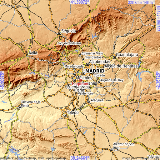
| \ | Map #1 | Map #2 | Topo.Map |
| Scale [m] | 595..709 m | 561..742 m | × |
| Scale [ft] | 1952..2326 ft | 1841..2434 ft | × |
| Average | 656.9 m = 2155 ft | 650 m = 2133 ft | × |
| Width | 7.45 km = 4.6 mi | 14.9 km = 9.3 mi | 238.4 km = 148.1 mi |
| Height | 7.45 km = 4.6 mi | 14.9 km = 9.3 mi | 238.4 km = 148.1 mi |
| ↑Max Latitude | 40.360674° | 40.394151° | 41.39072° |
| Latitude at center | 40.32718° | 40.32718° | 40.32718° |
| ↓Min Latitude | 40.293669° | 40.260142° | 39.24661° |
| ← Min Longitude | -3.807445° | -3.851391° | -5.16975° |
| Longitude center | -3.7635° | -3.7635° | -3.7635° |
| →Max Longitude | -3.719555° | -3.675609° | -2.35725° |
Nearby cities:
Cities around Leganés sort by population:
• Latina elevation 652 m
7 km,  12°
12°
• Carabanchel 622 m
7.8 km,  25°
25°
• Móstoles 667 m
8.6 km,  266°
266°
• Fuenlabrada 671 m
5.4 km,  208°
208°
• Alcorcón 729 m
5.6 km,  291°
291°
• Getafe 636 m
3.5 km,  132°
132°
• Arganzuela 605 m
9.9 km,  35°
35°
• Usera 586 m
8.7 km, 38°
• Villaverde 597 m
5.9 km,  64°
64°
• Parla 648 m
10.1 km,  181°
181°
• Pinto 612 m
10.9 km,  150°
150°
• Humanes de Madrid 680 m
10.3 km, 213°
Multilingual:
 En español:
Leganés elevación 672 m.
 En France:
Leganés élévation 672 m.


Sources and notes:
- [note 1] Map square and city borders are not equal. Map elevation data is calculated only from area inside that square.
- [src 1] Elevation data from geonames database provided with same terms of usage.
- [src 2] The elevation map of Leganés is generated using elevation data from NASA's 3 arcsec (90m) resolution SRTM data.
- [src 3] Base (background) map © OpenStreetMap contributors tiles are generated by Geofabrik and OpenTopoMap.
Copyright & License:
This Leganés Elevation Map is licensed under CC BY-SA. You may reuse any part from this page, if you give a proper credit by linking to this URL:
 More info on terms of use page.