Leza de Río Leza elevation
Leza de Río Leza (La Rioja, Provincia de La Rioja), Spain elevation is 572 meters and Leza de Río Leza elevation in feet is 1877 ft above sea level [src 1]. Leza de Río Leza is a seat of a third-order administrative division (feature code) with elevation that is 31 meters (102 ft) smaller than average city elevation in Spain.
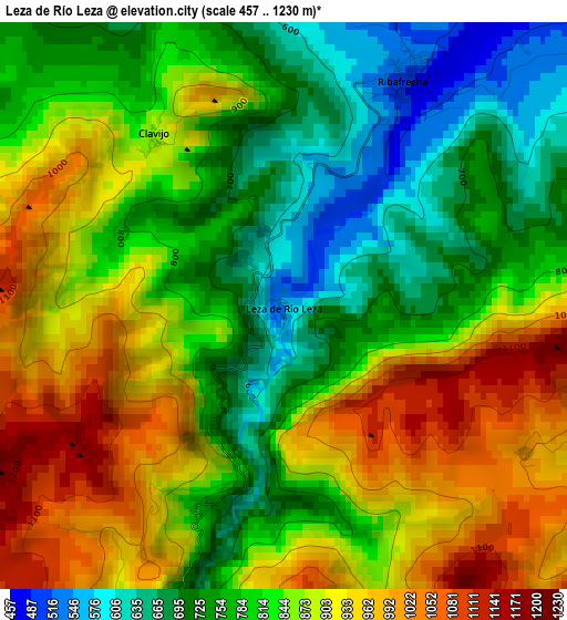
Below is the Elevation map of Leza de Río Leza, which displays elevation range with different colors. Scale of the first map is from 457 to 1230 m (1499 to 4035 ft) with average elevation of 836.7 meters (=2745 ft) [note 1]
These maps also provides idea of topography and contour of this city, they are displayed at different zoom levels. More info about maps, scale and edge coordinates you can find below images.
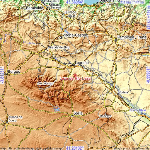
| \ | Map #1 | Topo.Map |
| Scale [m] | 457..1230 m | × |
| Scale [ft] | 1499..4035 ft | × |
| Average | 836.7 m = 2745 ft | × |
| Width | 7.22 km = 4.5 mi | 231.2 km = 143.7 mi |
| Height | 7.22 km = 4.5 mi | 231.2 km = 143.7 mi |
| ↑Max Latitude | 42.362° | 43.36054° |
| Latitude at center | 42.32952° | 42.32952° |
| ↓Min Latitude | 42.297024° | 41.28132° |
| ← Min Longitude | -2.450005° | -3.81231° |
| Longitude center | -2.40606° | -2.40606° |
| →Max Longitude | -2.362115° | -0.99981° |
Nearby cities:
Cities around Leza de Río Leza sort by population:
• Villamediana de Iregua elevation 445 m
10.8 km,  354°
354°
• Albelda de Iregua 545 m
6.4 km,  300°
300°
• Alberite 447 m
9 km,  342°
342°
• Murillo de Río Leza 418 m
10.4 km,  40°
40°
• Nalda 633 m
6.7 km,  274°
274°
• Lagunilla del Jubera 614 m
7 km,  85°
85°
• Viguera 706 m
10.7 km,  257°
257°
• Clavijo 871 m
2.7 km,  321°
321°
• Sorzano 715 m
10.2 km,  278°
278°
• Soto en Cameros 713 m
5.1 km,  198°
198°
• Robres del Castillo 726 m
11.1 km,  122°
122°
• Terroba 788 m
8.5 km, 201°
Multilingual:
 En español:
Leza de Río Leza elevación 572 m.
 En France:
Leza de Río Leza élévation 572 m.
 Auf Deutsch:
Leza de Río Leza höhe über dem Meeresspiegel ist 572 m.

Sources and notes:
- [note 1] Map square and city borders are not equal. Map elevation data is calculated only from area inside that square.
- [src 1] Elevation data from geonames database provided with same terms of usage.
- [src 2] The elevation map of Leza de Río Leza is generated using elevation data from NASA's 3 arcsec (90m) resolution SRTM data.
- [src 3] Base (background) map © OpenStreetMap contributors tiles are generated by Geofabrik and OpenTopoMap.
Copyright & License:
This Leza de Río Leza Elevation Map is licensed under CC BY-SA. You may reuse any part from this page, if you give a proper credit by linking to this URL:
 More info on terms of use page.