Maderuelo elevation
Maderuelo (Castille and León, Provincia de Segovia), Spain elevation is 958 meters and Maderuelo elevation in feet is 3143 ft above sea level [src 1]. Maderuelo is a seat of a third-order administrative division (feature code) with elevation that is 355 meters (1165 ft) bigger than average city elevation in Spain.
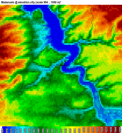
Below is the Elevation map of Maderuelo, which displays elevation range with different colors. Scale of the first map is from 904 to 1050 m (2966 to 3445 ft) with average elevation of 968.3 meters (=3177 ft) [note 1]
These maps also provides idea of topography and contour of this city, they are displayed at different zoom levels. More info about maps, scale and edge coordinates you can find below images.
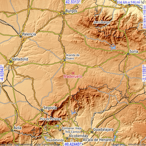
| \ | Map #1 | Topo.Map |
| Scale [m] | 904..1050 m | × |
| Scale [ft] | 2966..3445 ft | × |
| Average | 968.3 m = 3177 ft | × |
| Width | 7.32 km = 4.5 mi | 234.3 km = 145.6 mi |
| Height | 7.32 km = 4.5 mi | 234.3 km = 145.6 mi |
| ↑Max Latitude | 41.519352° | 42.5313° |
| Latitude at center | 41.48644° | 41.48644° |
| ↓Min Latitude | 41.453512° | 40.42445° |
| ← Min Longitude | -3.566125° | -4.92843° |
| Longitude center | -3.52218° | -3.52218° |
| →Max Longitude | -3.478235° | -2.11593° |
Nearby cities:
Cities around Maderuelo sort by population:
• Campo de San Pedro elevation 971 m
6.6 km,  197°
197°
• Castillejo de Robledo 960 m
8.3 km,  14°
14°
• Languilla 952 m
9.1 km,  116°
116°
• Cedillo de la Torre 1024 m
9.8 km,  225°
225°
• Corral de Ayllón 1028 m
11.9 km,  153°
153°
• Bercimuel 967 m
10.5 km, 202°
• Aldealengua de Santa María 946 m
5.3 km, 120°
• Riaguas de San Bartolomé 934 m
7.2 km,  157°
157°
• Alconada de Maderuelo 946 m
5.1 km,  142°
142°
• Villaverde de Montejo 1048 m
11.7 km,  289°
289°
• Cilleruelo de San Mamés 986 m
7.1 km,  211°
211°
• Valdevacas de Montejo 1122 m
10.2 km, 291°
Multilingual:
 En español:
Maderuelo elevación 958 m.
 En France:
Maderuelo élévation 958 m.
 Auf Deutsch:
Maderuelo höhe über dem Meeresspiegel ist 958 m.

Sources and notes:
- [note 1] Map square and city borders are not equal. Map elevation data is calculated only from area inside that square.
- [src 1] Elevation data from geonames database provided with same terms of usage.
- [src 2] The elevation map of Maderuelo is generated using elevation data from NASA's 3 arcsec (90m) resolution SRTM data.
- [src 3] Base (background) map © OpenStreetMap contributors tiles are generated by Geofabrik and OpenTopoMap.
Copyright & License:
This Maderuelo Elevation Map is licensed under CC BY-SA. You may reuse any part from this page, if you give a proper credit by linking to this URL:
 More info on terms of use page.