Manchones elevation
Manchones (Aragon, Provincia de Zaragoza), Spain elevation is 726 meters and Manchones elevation in feet is 2382 ft above sea level [src 1]. Manchones is a seat of a third-order administrative division (feature code) with elevation that is 123 meters (404 ft) bigger than average city elevation in Spain.
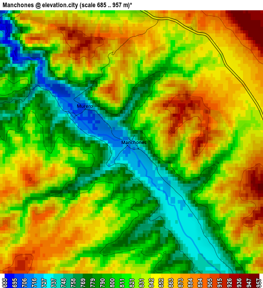
Below is the Elevation map of Manchones, which displays elevation range with different colors. Scale of the first map is from 685 to 957 m (2247 to 3140 ft) with average elevation of 825.7 meters (=2709 ft) [note 1]
These maps also provides idea of topography and contour of this city, they are displayed at different zoom levels. More info about maps, scale and edge coordinates you can find below images.
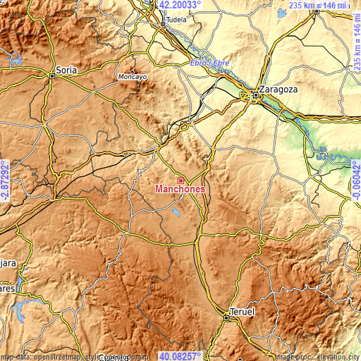
| \ | Map #1 | Topo.Map |
| Scale [m] | 685..957 m | × |
| Scale [ft] | 2247..3140 ft | × |
| Average | 825.7 m = 2709 ft | × |
| Width | 7.36 km = 4.6 mi | 235.5 km = 146.3 mi |
| Height | 7.36 km = 4.6 mi | 235.5 km = 146.3 mi |
| ↑Max Latitude | 41.183082° | 42.20033° |
| Latitude at center | 41.15° | 41.15° |
| ↓Min Latitude | 41.116901° | 40.08257° |
| ← Min Longitude | -1.510615° | -2.87292° |
| Longitude center | -1.46667° | -1.46667° |
| →Max Longitude | -1.422725° | -0.06042° |
Nearby cities:
Cities around Manchones sort by population:
• Daroca elevation 779 m
5.8 km,  132°
132°
• Villafeliche 687 m
6.2 km,  324°
324°
• Langa del Castillo 881 m
8.9 km,  39°
39°
• Atea 839 m
7.5 km,  279°
279°
• Montón 681 m
7.5 km,  327°
327°
• Murero 722 m
1.7 km,  308°
308°
• Retascón 881 m
7 km,  95°
95°
• Val de San Martín 1009 m
10.3 km,  171°
171°
• Valdehorna 885 m
9.3 km,  157°
157°
• Nombrevilla 919 m
10.2 km,  117°
117°
• Orcajo 927 m
4.9 km,  202°
202°
• Balconchán 885 m
7 km,  175°
175°
Multilingual:
 En español:
Manchones elevación 726 m.
 En France:
Manchones élévation 726 m.
 Auf Deutsch:
Manchones höhe über dem Meeresspiegel ist 726 m.

Sources and notes:
- [note 1] Map square and city borders are not equal. Map elevation data is calculated only from area inside that square.
- [src 1] Elevation data from geonames database provided with same terms of usage.
- [src 2] The elevation map of Manchones is generated using elevation data from NASA's 3 arcsec (90m) resolution SRTM data.
- [src 3] Base (background) map © OpenStreetMap contributors tiles are generated by Geofabrik and OpenTopoMap.
Copyright & License:
This Manchones Elevation Map is licensed under CC BY-SA. You may reuse any part from this page, if you give a proper credit by linking to this URL:
 More info on terms of use page.