Retascón elevation
Retascón (Aragon, Provincia de Zaragoza), Spain elevation is 881 meters and Retascón elevation in feet is 2890 ft above sea level [src 1]. Retascón is a seat of a third-order administrative division (feature code) with elevation that is 278 meters (912 ft) bigger than average city elevation in Spain.
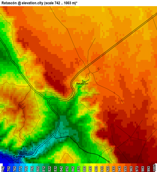
Below is the Elevation map of Retascón, which displays elevation range with different colors. Scale of the first map is from 742 to 1003 m (2434 to 3291 ft) with average elevation of 918 meters (=3012 ft) [note 1]
These maps also provides idea of topography and contour of this city, they are displayed at different zoom levels. More info about maps, scale and edge coordinates you can find below images.
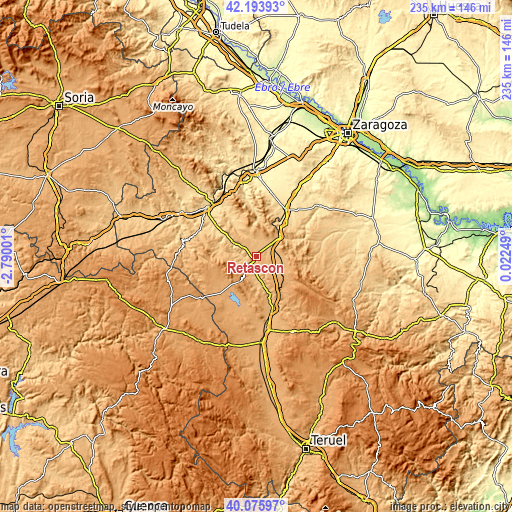
| \ | Map #1 | Topo.Map |
| Scale [m] | 742..1003 m | × |
| Scale [ft] | 2434..3291 ft | × |
| Average | 918 m = 3012 ft | × |
| Width | 7.36 km = 4.6 mi | 235.5 km = 146.3 mi |
| Height | 7.36 km = 4.6 mi | 235.5 km = 146.3 mi |
| ↑Max Latitude | 41.176585° | 42.19393° |
| Latitude at center | 41.1435° | 41.1435° |
| ↓Min Latitude | 41.110398° | 40.07597° |
| ← Min Longitude | -1.427705° | -2.79001° |
| Longitude center | -1.38376° | -1.38376° |
| →Max Longitude | -1.339815° | 0.02249° |
Nearby cities:
Cities around Retascón sort by population:
• Daroca elevation 779 m
4.1 km,  219°
219°
• San Martín del Río 800 m
8.6 km,  181°
181°
• Langa del Castillo 881 m
7.7 km,  350°
350°
• Mainar 870 m
8.7 km,  51°
51°
• Manchones 726 m
7 km,  275°
275°
• Murero 722 m
8.5 km, 282°
• Villadoz 893 m
8.3 km,  75°
75°
• Villarroya del Campo 925 m
5 km,  90°
90°
• Villanueva de Jiloca 770 m
7.5 km, 183°
• Torralbilla 888 m
8.3 km,  27°
27°
• Valdehorna 885 m
8.6 km,  203°
203°
• Nombrevilla 919 m
4.5 km,  152°
152°
Multilingual:
 En español:
Retascón elevación 881 m.
 En France:
Retascón élévation 881 m.
 Auf Deutsch:
Retascón höhe über dem Meeresspiegel ist 881 m.

Sources and notes:
- [note 1] Map square and city borders are not equal. Map elevation data is calculated only from area inside that square.
- [src 1] Elevation data from geonames database provided with same terms of usage.
- [src 2] The elevation map of Retascón is generated using elevation data from NASA's 3 arcsec (90m) resolution SRTM data.
- [src 3] Base (background) map © OpenStreetMap contributors tiles are generated by Geofabrik and OpenTopoMap.
Copyright & License:
This Retascón Elevation Map is licensed under CC BY-SA. You may reuse any part from this page, if you give a proper credit by linking to this URL:
 More info on terms of use page.