Masdenverge elevation
Masdenverge (Catalonia, Província de Tarragona), Spain elevation is 45 meters and Masdenverge elevation in feet is 148 ft above sea level [src 1]. Masdenverge is a populated place (feature code) with elevation that is 558 meters (1831 ft) smaller than average city elevation in Spain.
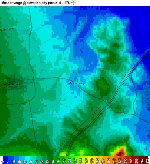
Below is the Elevation map of Masdenverge, which displays elevation range with different colors. Scale of the first map is from -4 to 278 m (-13 to 912 ft) with average elevation of 55 meters (=180 ft) [note 1]
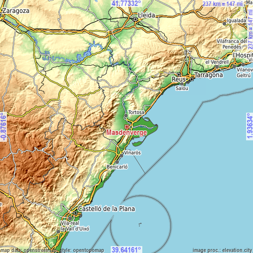
These maps also provides idea of topography and contour of this city, they are displayed at different zoom levels. More info about maps, scale and edge coordinates you can find below images.
| \ | Map #1 | Topo.Map |
| Scale [m] | -4..278 m | × |
| Scale [ft] | -13..912 ft | × |
| Average | 55 m = 180 ft | × |
| Width | 7.41 km = 4.6 mi | 237 km = 147.3 mi |
| Height | 7.41 km = 4.6 mi | 237 km = 147.3 mi |
| ↑Max Latitude | 40.7493° | 41.77332° |
| Latitude at center | 40.716° | 40.716° |
| ↓Min Latitude | 40.682683° | 39.64161° |
| ← Min Longitude | 0.486145° | -0.87616° |
| Longitude center | 0.53009° | 0.53009° |
| →Max Longitude | 0.574035° | 1.93634° |
Nearby cities:
Cities around Masdenverge sort by population:
• Tortosa elevation 18 m
10.8 km,  356°
356°
• Amposta 11 m
4.1 km,  99°
99°
• Sant Carles de la Ràpita 1 m
12.5 km,  151°
151°
• Deltebre 3 m
15 km,  88°
88°
• Alcanar 67 m
19.7 km,  192°
192°
• Ulldecona 141 m
14.9 km,  207°
207°
• Santa Bárbara 82 m
3.1 km,  268°
268°
• L'Ampolla 7 m
18.6 km,  54°
54°
• Les Cases d'Alcanar 10 m
18.1 km,  179°
179°
• Tivenys 23 m
21.4 km, 355°
• Mas de Barberans 375 m
13.9 km,  277°
277°
• Camarles 40 m
12.8 km,  55°
55°
Multilingual:
 En español:
Masdenverge elevación 45 m.
 En France:
Masdenverge élévation 45 m.
 Auf Deutsch:
Masdenverge höhe über dem Meeresspiegel ist 45 m.

Sources and notes:
- [note 1] Map square and city borders are not equal. Map elevation data is calculated only from area inside that square.
- [src 1] Elevation data from geonames database provided with same terms of usage.
- [src 2] The elevation map of Masdenverge is generated using elevation data from NASA's 3 arcsec (90m) resolution SRTM data.
- [src 3] Base (background) map © OpenStreetMap contributors tiles are generated by Geofabrik and OpenTopoMap.
Copyright & License:
This Masdenverge Elevation Map is licensed under CC BY-SA. You may reuse any part from this page, if you give a proper credit by linking to this URL:
 More info on terms of use page.