Mezalocha elevation
Mezalocha (Aragon, Provincia de Zaragoza), Spain elevation is 482 meters and Mezalocha elevation in feet is 1581 ft above sea level [src 1]. Mezalocha is a seat of a third-order administrative division (feature code) with elevation that is 121 meters (397 ft) smaller than average city elevation in Spain.
Below is the Elevation map of Mezalocha, which displays elevation range with different colors. Scale of the first map is from 418 to 686 m (1371 to 2251 ft) with average elevation of 525.1 meters (=1723 ft) [note 1]
These maps also provides idea of topography and contour of this city, they are displayed at different zoom levels. More info about maps, scale and edge coordinates you can find below images.
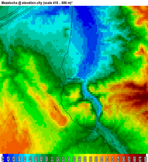
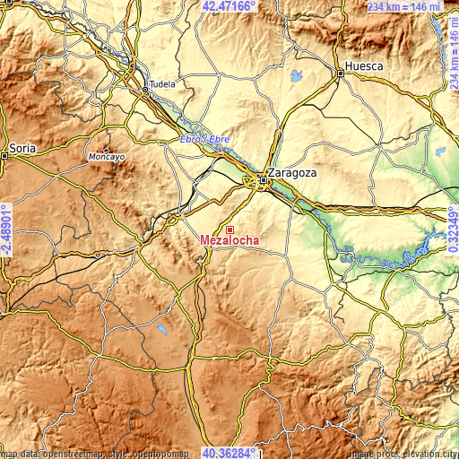
| \ | Map #1 | Topo.Map |
| Scale [m] | 418..686 m | × |
| Scale [ft] | 1371..2251 ft | × |
| Average | 525.1 m = 1723 ft | × |
| Width | 7.33 km = 4.6 mi | 234.5 km = 145.7 mi |
| Height | 7.33 km = 4.6 mi | 234.5 km = 145.7 mi |
| ↑Max Latitude | 41.458752° | 42.47166° |
| Latitude at center | 41.42581° | 41.42581° |
| ↓Min Latitude | 41.392851° | 40.36284° |
| ← Min Longitude | -1.126705° | -2.48901° |
| Longitude center | -1.08276° | -1.08276° |
| →Max Longitude | -1.038815° | 0.32349° |
Nearby cities:
Cities around Mezalocha sort by population:
• Cariñena elevation 599 m
15.4 km,  230°
230°
• María de Huerva 339 m
14.5 km,  29°
29°
• Alfamén 450 m
13.6 km,  276°
276°
• Muel 429 m
4.5 km,  357°
357°
• Longares 536 m
7.6 km,  250°
250°
• Botorrita 393 m
10 km, 25°
• Jaulín 513 m
8.1 km,  68°
68°
• Aguilón 687 m
14.9 km,  168°
168°
• Tosos 612 m
12.3 km,  176°
176°
• Fuendetodos 755 m
13.8 km,  132°
132°
• Mozota 397 m
6.6 km,  10°
10°
• Valmadrid 526 m
16.6 km,  83°
83°
Multilingual:
 En español:
Mezalocha elevación 482 m.
 En France:
Mezalocha élévation 482 m.
 Auf Deutsch:
Mezalocha höhe über dem Meeresspiegel ist 482 m.

Sources and notes:
- [note 1] Map square and city borders are not equal. Map elevation data is calculated only from area inside that square.
- [src 1] Elevation data from geonames database provided with same terms of usage.
- [src 2] The elevation map of Mezalocha is generated using elevation data from NASA's 3 arcsec (90m) resolution SRTM data.
- [src 3] Base (background) map © OpenStreetMap contributors tiles are generated by Geofabrik and OpenTopoMap.
Copyright & License:
This Mezalocha Elevation Map is licensed under CC BY-SA. You may reuse any part from this page, if you give a proper credit by linking to this URL:
 More info on terms of use page.