Monreal elevation
Monreal (Navarre, Provincia de Navarra), Spain elevation is 538 meters and Monreal elevation in feet is 1765 ft above sea level [src 1]. Monreal is a seat of a third-order administrative division (feature code) with elevation that is 65 meters (213 ft) smaller than average city elevation in Spain.
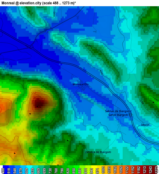
Below is the Elevation map of Monreal, which displays elevation range with different colors. Scale of the first map is from 488 to 1273 m (1601 to 4177 ft) with average elevation of 673.7 meters (=2210 ft) [note 1]
These maps also provides idea of topography and contour of this city, they are displayed at different zoom levels. More info about maps, scale and edge coordinates you can find below images.
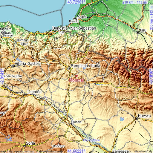
| \ | Map #1 | Topo.Map |
| Scale [m] | 488..1273 m | × |
| Scale [ft] | 1601..4177 ft | × |
| Average | 673.7 m = 2210 ft | × |
| Width | 7.18 km = 4.5 mi | 229.8 km = 142.8 mi |
| Height | 7.18 km = 4.5 mi | 229.8 km = 142.8 mi |
| ↑Max Latitude | 42.736495° | 43.72901° |
| Latitude at center | 42.70421° | 42.70421° |
| ↓Min Latitude | 42.671908° | 41.66221° |
| ← Min Longitude | -1.551795° | -2.9141° |
| Longitude center | -1.50785° | -1.50785° |
| →Max Longitude | -1.463905° | -0.1016° |
Nearby cities:
Cities around Monreal sort by population:
• Sarriguren elevation 460 m
14.2 km,  328°
328°
• Elorz 486 m
5.4 km,  305°
305°
• Huarte-Uharte 441 m
15.6 km, 334°
• Beriáin 495 m
11.6 km,  286°
286°
• Aoiz 510 m
14.3 km,  50°
50°
• Barásoain 530 m
15.9 km,  225°
225°
• Lizoáin 537 m
11 km,  17°
17°
• Olóriz 599 m
11.5 km, 228°
• Unzué 655 m
11.2 km,  239°
239°
• Orísoain 582 m
13.9 km,  214°
214°
• Lerga 618 m
15.2 km,  177°
177°
• Leache 595 m
13.6 km,  142°
142°
Multilingual:
 En español:
Monreal elevación 538 m.
 En France:
Monreal élévation 538 m.


Sources and notes:
- [note 1] Map square and city borders are not equal. Map elevation data is calculated only from area inside that square.
- [src 1] Elevation data from geonames database provided with same terms of usage.
- [src 2] The elevation map of Monreal is generated using elevation data from NASA's 3 arcsec (90m) resolution SRTM data.
- [src 3] Base (background) map © OpenStreetMap contributors tiles are generated by Geofabrik and OpenTopoMap.
Copyright & License:
This Monreal Elevation Map is licensed under CC BY-SA. You may reuse any part from this page, if you give a proper credit by linking to this URL:
 More info on terms of use page.