Orísoain elevation
Orísoain (Navarre, Provincia de Navarra), Spain elevation is 582 meters and Orísoain elevation in feet is 1909 ft above sea level [src 1]. Orísoain is a seat of a third-order administrative division (feature code) with elevation that is 21 meters (69 ft) smaller than average city elevation in Spain.
Below is the Elevation map of Orísoain, which displays elevation range with different colors. Scale of the first map is from 458 to 954 m (1503 to 3130 ft) with average elevation of 607.1 meters (=1992 ft) [note 1]
These maps also provides idea of topography and contour of this city, they are displayed at different zoom levels. More info about maps, scale and edge coordinates you can find below images.
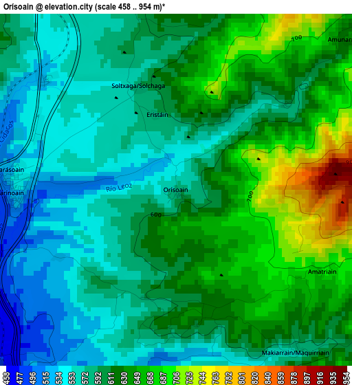
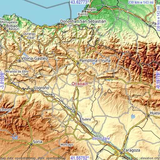
| \ | Map #1 | Topo.Map |
| Scale [m] | 458..954 m | × |
| Scale [ft] | 1503..3130 ft | × |
| Average | 607.1 m = 1992 ft | × |
| Width | 7.19 km = 4.5 mi | 230.2 km = 143 mi |
| Height | 7.19 km = 4.5 mi | 230.2 km = 143 mi |
| ↑Max Latitude | 42.633559° | 43.62773° |
| Latitude at center | 42.60122° | 42.60122° |
| ↓Min Latitude | 42.568864° | 41.55752° |
| ← Min Longitude | -1.647975° | -3.01028° |
| Longitude center | -1.60403° | -1.60403° |
| →Max Longitude | -1.560085° | -0.19778° |
Nearby cities:
Cities around Orísoain sort by population:
• Tafalla elevation 424 m
10.1 km,  214°
214°
• Barásoain 530 m
3.5 km,  273°
273°
• Garínoain 534 m
3.3 km, 268°
• San Martín de Unx 613 m
9.2 km,  157°
157°
• Pueyo 533 m
5.4 km,  222°
222°
• Enériz 427 m
12.8 km,  307°
307°
• Olóriz 599 m
3.8 km,  349°
349°
• Eslava 556 m
12.5 km,  108°
108°
• Unzué 655 m
6 km,  342°
342°
• Lerga 618 m
9.2 km, 113°
• Tirapu 503 m
10.2 km, 307°
• Añorbe 577 m
11 km,  304°
304°
Multilingual:
 En español:
Orísoain elevación 582 m.
 En France:
Orísoain élévation 582 m.
 Auf Deutsch:
Orísoain höhe über dem Meeresspiegel ist 582 m.

Sources and notes:
- [note 1] Map square and city borders are not equal. Map elevation data is calculated only from area inside that square.
- [src 1] Elevation data from geonames database provided with same terms of usage.
- [src 2] The elevation map of Orísoain is generated using elevation data from NASA's 3 arcsec (90m) resolution SRTM data.
- [src 3] Base (background) map © OpenStreetMap contributors tiles are generated by Geofabrik and OpenTopoMap.
Copyright & License:
This Orísoain Elevation Map is licensed under CC BY-SA. You may reuse any part from this page, if you give a proper credit by linking to this URL:
 More info on terms of use page.