Navalagamella elevation
Navalagamella (Madrid, Provincia de Madrid), Spain elevation is 760 meters and Navalagamella elevation in feet is 2493 ft above sea level [src 1]. Navalagamella is a seat of a third-order administrative division (feature code) with elevation that is 157 meters (515 ft) bigger than average city elevation in Spain.
Below is the Elevation map of Navalagamella, which displays elevation range with different colors. Scale of the first map is from 553 to 959 m (1814 to 3146 ft) with average elevation of 770.8 meters (=2529 ft) [note 1]
These maps also provides idea of topography and contour of this city, they are displayed at different zoom levels. More info about maps, scale and edge coordinates you can find below images.
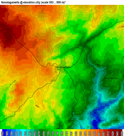
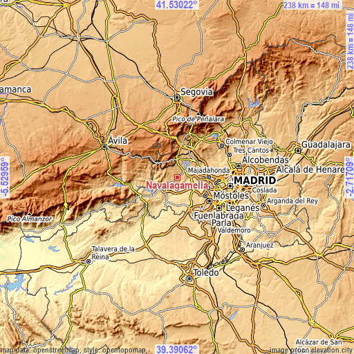
| \ | Map #1 | Topo.Map |
| Scale [m] | 553..959 m | × |
| Scale [ft] | 1814..3146 ft | × |
| Average | 770.8 m = 2529 ft | × |
| Width | 7.43 km = 4.6 mi | 237.9 km = 147.8 mi |
| Height | 7.43 km = 4.6 mi | 237.9 km = 147.8 mi |
| ↑Max Latitude | 40.502363° | 41.53022° |
| Latitude at center | 40.46894° | 40.46894° |
| ↓Min Latitude | 40.4355° | 39.39062° |
| ← Min Longitude | -4.167285° | -5.52959° |
| Longitude center | -4.12334° | -4.12334° |
| →Max Longitude | -4.079395° | -2.71709° |
Nearby cities:
Cities around Navalagamella sort by population:
• Villanueva de la Cañada elevation 655 m
10.4 km,  103°
103°
• Villanueva del Pardillo 654 m
13.7 km,  80°
80°
• El Escorial 917 m
12.6 km,  358°
358°
• Valdemorillo 811 m
5.9 km,  53°
53°
• Brunete 654 m
12.7 km,  123°
123°
• Colmenarejo 871 m
13.6 km,  41°
41°
• Robledo de Chavela 895 m
10.2 km,  290°
290°
• Quijorna 572 m
7.3 km,  129°
129°
• Chapinería 680 m
12.4 km,  216°
216°
• Zarzalejo 1110 m
10.1 km,  330°
330°
• Colmenar del Arroyo 681 m
8.4 km,  228°
228°
• Fresnedillas 896 m
4.5 km,  296°
296°
Multilingual:
 En español:
Navalagamella elevación 760 m.
 En France:
Navalagamella élévation 760 m.
 Auf Deutsch:
Navalagamella höhe über dem Meeresspiegel ist 760 m.

Sources and notes:
- [note 1] Map square and city borders are not equal. Map elevation data is calculated only from area inside that square.
- [src 1] Elevation data from geonames database provided with same terms of usage.
- [src 2] The elevation map of Navalagamella is generated using elevation data from NASA's 3 arcsec (90m) resolution SRTM data.
- [src 3] Base (background) map © OpenStreetMap contributors tiles are generated by Geofabrik and OpenTopoMap.
Copyright & License:
This Navalagamella Elevation Map is licensed under CC BY-SA. You may reuse any part from this page, if you give a proper credit by linking to this URL:
 More info on terms of use page.