Nieva elevation
Nieva (Castille and León, Provincia de Segovia), Spain elevation is 841 meters and Nieva elevation in feet is 2759 ft above sea level [src 1]. Nieva is a seat of a third-order administrative division (feature code) with elevation that is 238 meters (781 ft) bigger than average city elevation in Spain.
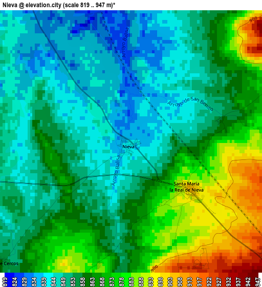
Below is the Elevation map of Nieva, which displays elevation range with different colors. Scale of the first map is from 819 to 947 m (2687 to 3107 ft) with average elevation of 859.6 meters (=2820 ft) [note 1]
These maps also provides idea of topography and contour of this city, they are displayed at different zoom levels. More info about maps, scale and edge coordinates you can find below images.
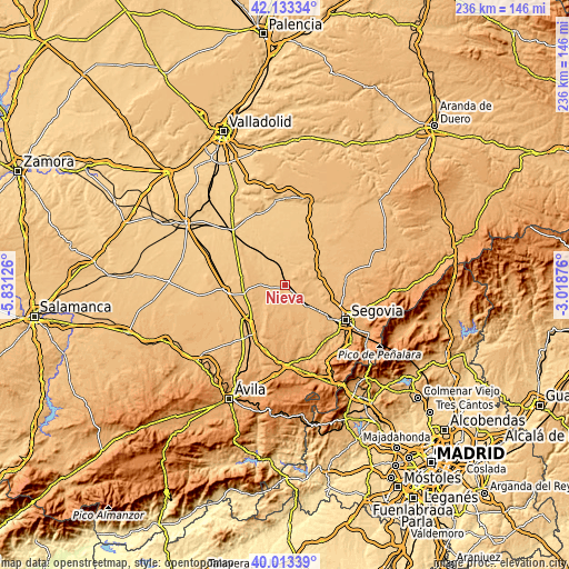
| \ | Map #1 | Topo.Map |
| Scale [m] | 819..947 m | × |
| Scale [ft] | 2687..3107 ft | × |
| Average | 859.6 m = 2820 ft | × |
| Width | 7.37 km = 4.6 mi | 235.7 km = 146.5 mi |
| Height | 7.37 km = 4.6 mi | 235.7 km = 146.5 mi |
| ↑Max Latitude | 41.115026° | 42.13334° |
| Latitude at center | 41.08191° | 41.08191° |
| ↓Min Latitude | 41.048777° | 40.01339° |
| ← Min Longitude | -4.468955° | -5.83126° |
| Longitude center | -4.42501° | -4.42501° |
| →Max Longitude | -4.381065° | -3.01876° |
Nearby cities:
Cities around Nieva sort by population:
• Nava de la Asunción elevation 809 m
9.7 km,  327°
327°
• Santa María la Real de Nieva 900 m
2 km,  131°
131°
• Bernardos 905 m
8 km,  50°
50°
• Juarros de Voltoya 853 m
9.7 km,  234°
234°
• Armuña 908 m
8.9 km,  93°
93°
• Aldeanueva del Codonal 859 m
9.9 km,  270°
270°
• Migueláñez 888 m
6.7 km, 49°
• Añe 879 m
12 km,  114°
114°
• Ortigosa de Pestaño 859 m
2.6 km,  76°
76°
• Domingo García 903 m
5.3 km, 45°
• Aldehuela del Codonal 861 m
10 km,  252°
252°
• Melque de Cercos 861 m
5 km, 227°
Multilingual:
 En español:
Nieva elevación 841 m.
 En France:
Nieva élévation 841 m.


Sources and notes:
- [note 1] Map square and city borders are not equal. Map elevation data is calculated only from area inside that square.
- [src 1] Elevation data from geonames database provided with same terms of usage.
- [src 2] The elevation map of Nieva is generated using elevation data from NASA's 3 arcsec (90m) resolution SRTM data.
- [src 3] Base (background) map © OpenStreetMap contributors tiles are generated by Geofabrik and OpenTopoMap.
Copyright & License:
This Nieva Elevation Map is licensed under CC BY-SA. You may reuse any part from this page, if you give a proper credit by linking to this URL:
 More info on terms of use page.