Oion / Oyón elevation
Oion / Oyón (Basque Country, Araba / Álava), Spain elevation is 436 meters and Oion / Oyón elevation in feet is 1430 ft above sea level [src 1]. Oion / Oyón is a populated place (feature code) with elevation that is 167 meters (548 ft) smaller than average city elevation in Spain.
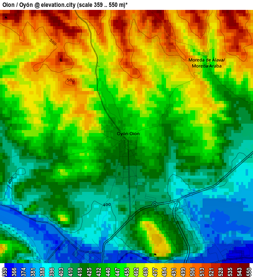
Below is the Elevation map of Oion / Oyón, which displays elevation range with different colors. Scale of the first map is from 359 to 550 m (1178 to 1804 ft) with average elevation of 441.7 meters (=1449 ft) [note 1]
These maps also provides idea of topography and contour of this city, they are displayed at different zoom levels. More info about maps, scale and edge coordinates you can find below images.
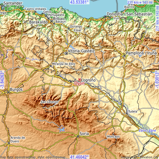
| \ | Map #1 | Topo.Map |
| Scale [m] | 359..550 m | × |
| Scale [ft] | 1178..1804 ft | × |
| Average | 441.7 m = 1449 ft | × |
| Width | 7.2 km = 4.5 mi | 230.5 km = 143.2 mi |
| Height | 7.2 km = 4.5 mi | 230.5 km = 143.2 mi |
| ↑Max Latitude | 42.538099° | 43.53381° |
| Latitude at center | 42.50571° | 42.50571° |
| ↓Min Latitude | 42.473305° | 41.46042° |
| ← Min Longitude | -2.480325° | -3.84263° |
| Longitude center | -2.43638° | -2.43638° |
| →Max Longitude | -2.392435° | -1.03013° |
Nearby cities:
Cities around Oion / Oyón sort by population:
• Logroño elevation 389 m
4.5 km,  194°
194°
• Lardero 438 m
9 km, 193°
• Villamediana de Iregua 445 m
8.9 km,  171°
171°
• Fuenmayor 435 m
11.1 km,  247°
247°
• Alberite 447 m
11 km,  181°
181°
• Lapuebla de Labarca 434 m
11.3 km,  263°
263°
• Bargota 593 m
11.9 km,  59°
59°
• Moreda Araba / Moreda de Álava 462 m
3.2 km,  46°
46°
• Aras 638 m
9.1 km, 46°
• Lapoblación 969 m
11.2 km,  350°
350°
• Aguilar de Codés 721 m
12.5 km,  17°
17°
• Viana 469 m
5.5 km,  78°
78°
Multilingual:
 En español:
Oyón elevación 436 m.
 En France:
Oion / Oyón élévation 436 m.
 Auf Deutsch:
Oion / Oyón höhe über dem Meeresspiegel ist 436 m.

Sources and notes:
- [note 1] Map square and city borders are not equal. Map elevation data is calculated only from area inside that square.
- [src 1] Elevation data from geonames database provided with same terms of usage.
- [src 2] The elevation map of Oion / Oyón is generated using elevation data from NASA's 3 arcsec (90m) resolution SRTM data.
- [src 3] Base (background) map © OpenStreetMap contributors tiles are generated by Geofabrik and OpenTopoMap.
Copyright & License:
This Oion / Oyón Elevation Map is licensed under CC BY-SA. You may reuse any part from this page, if you give a proper credit by linking to this URL:
 More info on terms of use page.