Palencia elevation
Palencia (Castille and León, Provincia de Palencia), Spain elevation is 739 meters and Palencia elevation in feet is 2425 ft above sea level [src 1]. Palencia is a seat of a second-order administrative division (feature code) with elevation that is 136 meters (446 ft) bigger than average city elevation in Spain.
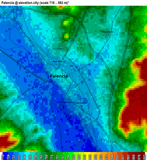
Below is the Elevation map of Palencia, which displays elevation range with different colors. Scale of the first map is from 718 to 882 m (2356 to 2894 ft) with average elevation of 758.4 meters (=2488 ft) [note 1]
These maps also provides idea of topography and contour of this city, they are displayed at different zoom levels. More info about maps, scale and edge coordinates you can find below images.
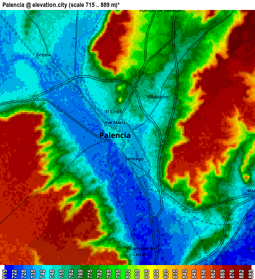
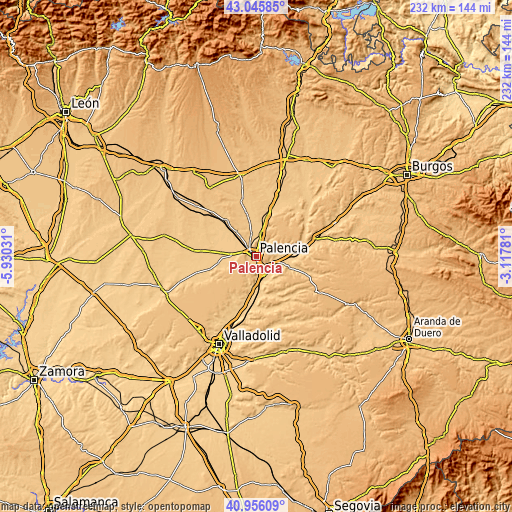
| \ | Map #1 | Map #2 | Topo.Map |
| Scale [m] | 718..882 m | 715..889 m | × |
| Scale [ft] | 2356..2894 ft | 2346..2917 ft | × |
| Average | 758.4 m = 2488 ft | 791.2 m = 2596 ft | × |
| Width | 7.26 km = 4.5 mi | 14.52 km = 9 mi | 232.4 km = 144.4 mi |
| Height | 7.26 km = 4.5 mi | 14.52 km = 9 mi | 232.4 km = 144.4 mi |
| ↑Max Latitude | 42.042194° | 42.074822° | 43.04585° |
| Latitude at center | 42.00955° | 42.00955° | 42.00955° |
| ↓Min Latitude | 41.976889° | 41.944211° | 40.95609° |
| ← Min Longitude | -4.568005° | -4.611951° | -5.93031° |
| Longitude center | -4.52406° | -4.52406° | -4.52406° |
| →Max Longitude | -4.480115° | -4.436169° | -3.11781° |
Nearby cities:
Cities around Palencia sort by population:
• Venta de Baños elevation 724 m
10.2 km,  164°
164°
• Villamuriel de Cerrato 726 m
6.7 km,  174°
174°
• Grijota 747 m
6.9 km,  314°
314°
• Villaumbrales 760 m
11.5 km,  319°
319°
• Villalobón 755 m
2.9 km,  36°
36°
• Monzón de Campos 755 m
12.1 km,  12°
12°
• Autilla del Pino 869 m
9.3 km,  257°
257°
• Fuentes de Valdepero 799 m
7.6 km, 14°
• Soto de Cerrato 727 m
10 km,  128°
128°
• Husillos 744 m
9 km,  358°
358°
• Villamartín de Campos 748 m
11.6 km,  273°
273°
• Valdeolmillos 784 m
10.8 km,  71°
71°
Multilingual:
 En español:
Palencia elevación 739 m.
 En France:
Palencia élévation 739 m.
 Auf Deutsch:
Palencia höhe über dem Meeresspiegel ist 739 m.

Sources and notes:
- [note 1] Map square and city borders are not equal. Map elevation data is calculated only from area inside that square.
- [src 1] Elevation data from geonames database provided with same terms of usage.
- [src 2] The elevation map of Palencia is generated using elevation data from NASA's 3 arcsec (90m) resolution SRTM data.
- [src 3] Base (background) map © OpenStreetMap contributors tiles are generated by Geofabrik and OpenTopoMap.
Copyright & License:
This Palencia Elevation Map is licensed under CC BY-SA. You may reuse any part from this page, if you give a proper credit by linking to this URL:
 More info on terms of use page.