Pesoz elevation
Pesoz (Asturias, Province of Asturias), Spain elevation is 613 meters and Pesoz elevation in feet is 2011 ft above sea level [src 1]. Pesoz is a seat of a third-order administrative division (feature code) with elevation that is 10 meters (33 ft) bigger than average city elevation in Spain.
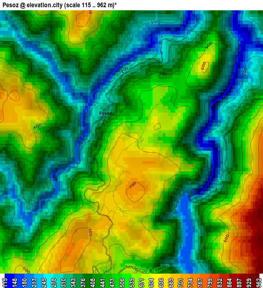
Below is the Elevation map of Pesoz, which displays elevation range with different colors. Scale of the first map is from 115 to 962 m (377 to 3156 ft) with average elevation of 451.9 meters (=1483 ft) [note 1]
These maps also provides idea of topography and contour of this city, they are displayed at different zoom levels. More info about maps, scale and edge coordinates you can find below images.
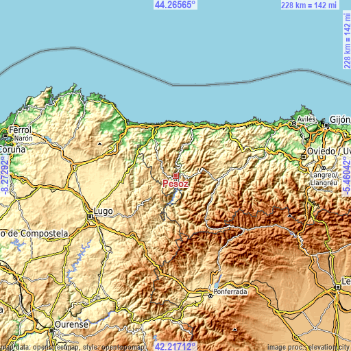
| \ | Map #1 | Topo.Map |
| Scale [m] | 115..962 m | × |
| Scale [ft] | 377..3156 ft | × |
| Average | 451.9 m = 1483 ft | × |
| Width | 7.12 km = 4.4 mi | 227.8 km = 141.5 mi |
| Height | 7.12 km = 4.4 mi | 227.8 km = 141.5 mi |
| ↑Max Latitude | 43.282° | 44.26565° |
| Latitude at center | 43.25° | 43.25° |
| ↓Min Latitude | 43.217983° | 42.21712° |
| ← Min Longitude | -6.910615° | -8.27292° |
| Longitude center | -6.86667° | -6.86667° |
| →Max Longitude | -6.822725° | -5.46042° |
Nearby cities:
Cities around Pesoz sort by population:
• Cangas del Narcea elevation 368 m
26.7 km,  106°
106°
• Fonsagrada 962 m
21.5 km,  229°
229°
• Pola de Allande 556 m
20 km,  82°
82°
• Boal 412 m
20.7 km,  11°
11°
• San Antolín 335 m
23.5 km,  181°
181°
• Vilaión 372 m
25.6 km,  30°
30°
• Grandas de Salime 554 m
3.9 km,  190°
190°
• Taramundi 251 m
23.1 km,  302°
302°
• Santa Eulalia de Oscos 558 m
12.4 km,  274°
274°
• Illano 419 m
9.3 km,  0°
0°
• San Martín de Oscos 713 m
8 km,  282°
282°
• Villanueva de Oscos 646 m
11.9 km,  305°
305°
Multilingual:
 En español:
Pesoz elevación 613 m.
 En France:
Pesoz élévation 613 m.


Sources and notes:
- [note 1] Map square and city borders are not equal. Map elevation data is calculated only from area inside that square.
- [src 1] Elevation data from geonames database provided with same terms of usage.
- [src 2] The elevation map of Pesoz is generated using elevation data from NASA's 3 arcsec (90m) resolution SRTM data.
- [src 3] Base (background) map © OpenStreetMap contributors tiles are generated by Geofabrik and OpenTopoMap.
Copyright & License:
This Pesoz Elevation Map is licensed under CC BY-SA. You may reuse any part from this page, if you give a proper credit by linking to this URL:
 More info on terms of use page.