San Antolín elevation
San Antolín (Asturias, Province of Asturias), Spain elevation is 335 meters and San Antolín elevation in feet is 1099 ft above sea level [src 1]. San Antolín is a populated place (feature code) with elevation that is 268 meters (879 ft) smaller than average city elevation in Spain.
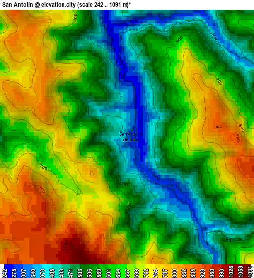
Below is the Elevation map of San Antolín, which displays elevation range with different colors. Scale of the first map is from 242 to 1091 m (794 to 3579 ft) with average elevation of 629.5 meters (=2065 ft) [note 1]
These maps also provides idea of topography and contour of this city, they are displayed at different zoom levels. More info about maps, scale and edge coordinates you can find below images.
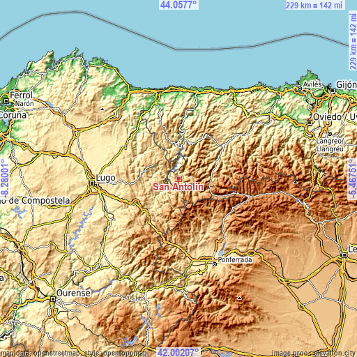
| \ | Map #1 | Topo.Map |
| Scale [m] | 242..1091 m | × |
| Scale [ft] | 794..3579 ft | × |
| Average | 629.5 m = 2065 ft | × |
| Width | 7.14 km = 4.4 mi | 228.6 km = 142 mi |
| Height | 7.14 km = 4.4 mi | 228.6 km = 142 mi |
| ↑Max Latitude | 43.070601° | 44.0577° |
| Latitude at center | 43.03849° | 43.03849° |
| ↓Min Latitude | 43.006362° | 42.00207° |
| ← Min Longitude | -6.917705° | -8.28001° |
| Longitude center | -6.87376° | -6.87376° |
| →Max Longitude | -6.829815° | -5.46751° |
Nearby cities:
Cities around San Antolín sort by population:
• Cangas del Narcea elevation 368 m
30.8 km,  58°
58°
• Fonsagrada 962 m
18.4 km,  301°
301°
• Becerreá 634 m
31.1 km,  229°
229°
• San Román 665 m
24.3 km,  219°
219°
• Navia de Suarna 292 m
13 km, 232°
• Degaña 848 m
27.1 km,  113°
113°
• Grandas de Salime 554 m
19.7 km,  359°
359°
• Santa Eulalia de Oscos 558 m
27.3 km,  334°
334°
• San Martín de Oscos 713 m
26.3 km,  344°
344°
• Candín 892 m
27.3 km,  154°
154°
• Peranzanes 958 m
26.5 km,  132°
132°
• Pesoz 613 m
23.5 km,  1°
1°
Multilingual:
 En español:
San Antolín elevación 335 m.
 En France:
San Antolín élévation 335 m.
 Auf Deutsch:
San Antolín höhe über dem Meeresspiegel ist 335 m.

Sources and notes:
- [note 1] Map square and city borders are not equal. Map elevation data is calculated only from area inside that square.
- [src 1] Elevation data from geonames database provided with same terms of usage.
- [src 2] The elevation map of San Antolín is generated using elevation data from NASA's 3 arcsec (90m) resolution SRTM data.
- [src 3] Base (background) map © OpenStreetMap contributors tiles are generated by Geofabrik and OpenTopoMap.
Copyright & License:
This San Antolín Elevation Map is licensed under CC BY-SA. You may reuse any part from this page, if you give a proper credit by linking to this URL:
 More info on terms of use page.