Pitillas elevation
Pitillas (Navarre, Provincia de Navarra), Spain elevation is 347 meters and Pitillas elevation in feet is 1138 ft above sea level [src 1]. Pitillas is a seat of a third-order administrative division (feature code) with elevation that is 256 meters (840 ft) smaller than average city elevation in Spain.
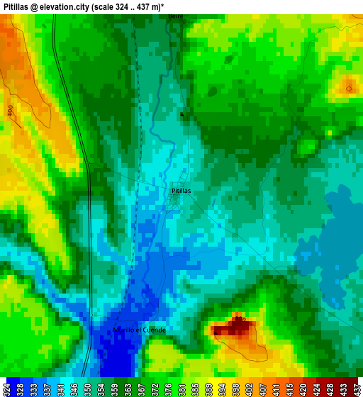
Below is the Elevation map of Pitillas, which displays elevation range with different colors. Scale of the first map is from 324 to 437 m (1063 to 1434 ft) with average elevation of 363.6 meters (=1193 ft) [note 1]
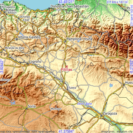
These maps also provides idea of topography and contour of this city, they are displayed at different zoom levels. More info about maps, scale and edge coordinates you can find below images.
| \ | Map #1 | Topo.Map |
| Scale [m] | 324..437 m | × |
| Scale [ft] | 1063..1434 ft | × |
| Average | 363.6 m = 1193 ft | × |
| Width | 7.21 km = 4.5 mi | 230.8 km = 143.4 mi |
| Height | 7.21 km = 4.5 mi | 230.8 km = 143.4 mi |
| ↑Max Latitude | 42.454152° | 43.45121° |
| Latitude at center | 42.42172° | 42.42172° |
| ↓Min Latitude | 42.389271° | 41.37504° |
| ← Min Longitude | -1.664115° | -3.02642° |
| Longitude center | -1.62017° | -1.62017° |
| →Max Longitude | -1.576225° | -0.21392° |
Nearby cities:
Cities around Pitillas sort by population:
• Tafalla elevation 424 m
12.5 km,  339°
339°
• Olite 394 m
7 km, 337°
• Andosilla 333 m
6.2 km,  224°
224°
• Marcilla 293 m
14.2 km, 222°
• Falces 291 m
14.6 km,  255°
255°
• Caparroso 303 m
9.3 km,  195°
195°
• Santacara 313 m
6.2 km,  190°
190°
• Mélida 350 m
9.1 km,  140°
140°
• Murillo el Fruto 360 m
13.5 km,  103°
103°
• San Martín de Unx 613 m
12.4 km,  22°
22°
• Beire 371 m
3.6 km,  358°
358°
• Ujué 638 m
13.2 km,  48°
48°
Multilingual:
 En español:
Pitillas elevación 347 m.
 En France:
Pitillas élévation 347 m.
 Auf Deutsch:
Pitillas höhe über dem Meeresspiegel ist 347 m.

Sources and notes:
- [note 1] Map square and city borders are not equal. Map elevation data is calculated only from area inside that square.
- [src 1] Elevation data from geonames database provided with same terms of usage.
- [src 2] The elevation map of Pitillas is generated using elevation data from NASA's 3 arcsec (90m) resolution SRTM data.
- [src 3] Base (background) map © OpenStreetMap contributors tiles are generated by Geofabrik and OpenTopoMap.
Copyright & License:
This Pitillas Elevation Map is licensed under CC BY-SA. You may reuse any part from this page, if you give a proper credit by linking to this URL:
 More info on terms of use page.