Ribadavia elevation
Ribadavia (Galicia, Provincia de Ourense), Spain elevation is 96 meters and Ribadavia elevation in feet is 315 ft above sea level [src 1]. Ribadavia is a seat of a third-order administrative division (feature code) with elevation that is 507 meters (1663 ft) smaller than average city elevation in Spain.
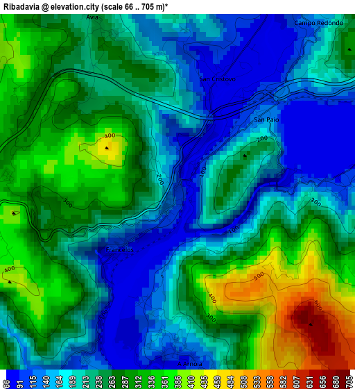
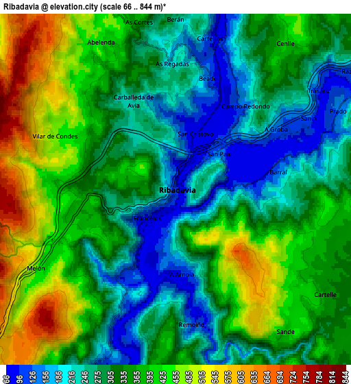
Below is the Elevation map of Ribadavia, which displays elevation range with different colors. Scale of the first map is from 66 to 705 m (217 to 2313 ft) with average elevation of 238.6 meters (=783 ft) [note 1]
These maps also provides idea of topography and contour of this city, they are displayed at different zoom levels. More info about maps, scale and edge coordinates you can find below images.
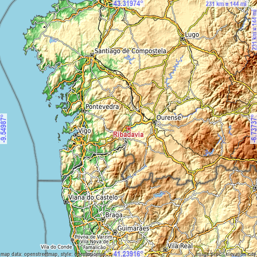
| \ | Map #1 | Map #2 | Topo.Map |
| Scale [m] | 66..705 m | 66..844 m | × |
| Scale [ft] | 217..2313 ft | 217..2769 ft | × |
| Average | 238.6 m = 783 ft | 336.9 m = 1105 ft | × |
| Width | 7.23 km = 4.5 mi | 14.46 km = 9 mi | 231.3 km = 143.7 mi |
| Height | 7.23 km = 4.5 mi | 14.46 km = 9 mi | 231.3 km = 143.7 mi |
| ↑Max Latitude | 42.320541° | 42.353025° | 43.31974° |
| Latitude at center | 42.28804° | 42.28804° | 42.28804° |
| ↓Min Latitude | 42.255522° | 42.222987° | 41.23916° |
| ← Min Longitude | -8.187565° | -8.231511° | -9.54987° |
| Longitude center | -8.14362° | -8.14362° | -8.14362° |
| →Max Longitude | -8.099675° | -8.055729° | -6.73737° |
Nearby cities:
Cities around Ribadavia sort by population:
• Cartelle elevation 362 m
7.3 km,  124°
124°
• Boborás 429 m
16.2 km,  359°
359°
• Avión 549 m
13.7 km,  320°
320°
• Toén 369 m
15.9 km,  78°
78°
• Castrelo de Miño 218 m
6.4 km, 80°
• Carballeda de Avia 261 m
4.1 km,  335°
335°
• Melón 470 m
6.6 km,  241°
241°
• Cenlle 408 m
7.4 km,  36°
36°
• San Amaro 488 m
11.1 km,  31°
31°
• Beade 145 m
4.9 km,  13°
13°
• Punxín 307 m
14.3 km,  49°
49°
• Cortegada 141 m
8.9 km,  193°
193°
Multilingual:
 En español:
Ribadavia elevación 96 m.
 En France:
Ribadavia élévation 96 m.
 Auf Deutsch:
Ribadavia höhe über dem Meeresspiegel ist 96 m.

Sources and notes:
- [note 1] Map square and city borders are not equal. Map elevation data is calculated only from area inside that square.
- [src 1] Elevation data from geonames database provided with same terms of usage.
- [src 2] The elevation map of Ribadavia is generated using elevation data from NASA's 3 arcsec (90m) resolution SRTM data.
- [src 3] Base (background) map © OpenStreetMap contributors tiles are generated by Geofabrik and OpenTopoMap.
Copyright & License:
This Ribadavia Elevation Map is licensed under CC BY-SA. You may reuse any part from this page, if you give a proper credit by linking to this URL:
 More info on terms of use page.