Sacramenia elevation
Sacramenia (Castille and León, Provincia de Segovia), Spain elevation is 834 meters and Sacramenia elevation in feet is 2736 ft above sea level [src 1]. Sacramenia is a seat of a third-order administrative division (feature code) with elevation that is 231 meters (758 ft) bigger than average city elevation in Spain.
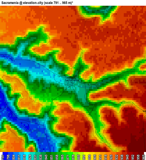
Below is the Elevation map of Sacramenia, which displays elevation range with different colors. Scale of the first map is from 791 to 965 m (2595 to 3166 ft) with average elevation of 897.5 meters (=2945 ft) [note 1]
These maps also provides idea of topography and contour of this city, they are displayed at different zoom levels. More info about maps, scale and edge coordinates you can find below images.
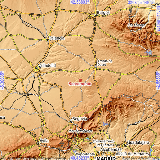
| \ | Map #1 | Topo.Map |
| Scale [m] | 791..965 m | × |
| Scale [ft] | 2595..3166 ft | × |
| Average | 897.5 m = 2945 ft | × |
| Width | 7.32 km = 4.5 mi | 234.2 km = 145.5 mi |
| Height | 7.32 km = 4.5 mi | 234.2 km = 145.5 mi |
| ↑Max Latitude | 41.527098° | 42.53893° |
| Latitude at center | 41.49419° | 41.49419° |
| ↓Min Latitude | 41.461266° | 40.43233° |
| ← Min Longitude | -4.006045° | -5.36835° |
| Longitude center | -3.9621° | -3.9621° |
| →Max Longitude | -3.918155° | -2.55585° |
Nearby cities:
Cities around Sacramenia sort by population:
• Fuentesaúco de Fuentidueña elevation 899 m
11.4 km,  227°
227°
• Rábano 779 m
9.4 km,  297°
297°
• Cuevas de Provanco 889 m
5.3 km,  0°
0°
• Fuentesoto 938 m
5.5 km,  138°
138°
• Fuentidueña 832 m
5.9 km,  193°
193°
• Castrillo de Duero 801 m
10 km,  333°
333°
• Valtiendas 914 m
4.1 km,  115°
115°
• Laguna de Contreras 800 m
5.6 km,  271°
271°
• Torreadrada 1082 m
11.6 km, 118°
• Olmos de Peñafiel 790 m
10.9 km,  321°
321°
• Aldeasoña 850 m
8.3 km,  253°
253°
• Torre de Peñafiel 791 m
11.5 km,  294°
294°
Multilingual:
 En español:
Sacramenia elevación 834 m.
 En France:
Sacramenia élévation 834 m.
 Auf Deutsch:
Sacramenia höhe über dem Meeresspiegel ist 834 m.

Sources and notes:
- [note 1] Map square and city borders are not equal. Map elevation data is calculated only from area inside that square.
- [src 1] Elevation data from geonames database provided with same terms of usage.
- [src 2] The elevation map of Sacramenia is generated using elevation data from NASA's 3 arcsec (90m) resolution SRTM data.
- [src 3] Base (background) map © OpenStreetMap contributors tiles are generated by Geofabrik and OpenTopoMap.
Copyright & License:
This Sacramenia Elevation Map is licensed under CC BY-SA. You may reuse any part from this page, if you give a proper credit by linking to this URL:
 More info on terms of use page.