Salou elevation
Salou (Catalonia, Província de Tarragona), Spain elevation is 6 meters and Salou elevation in feet is 20 ft above sea level [src 1]. Salou is a populated place (feature code) with elevation that is 597 meters (1959 ft) smaller than average city elevation in Spain.
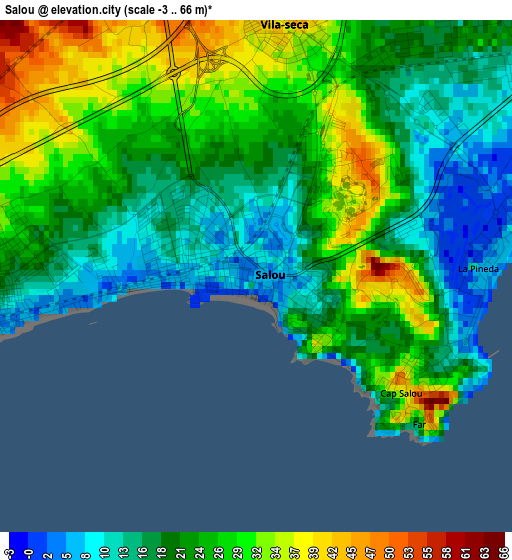
Below is the Elevation map of Salou, which displays elevation range with different colors. Scale of the first map is from -3 to 66 m (-10 to 217 ft) with average elevation of 22.8 meters (=75 ft) [note 1]
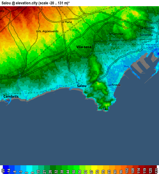
These maps also provides idea of topography and contour of this city, they are displayed at different zoom levels. More info about maps, scale and edge coordinates you can find below images.
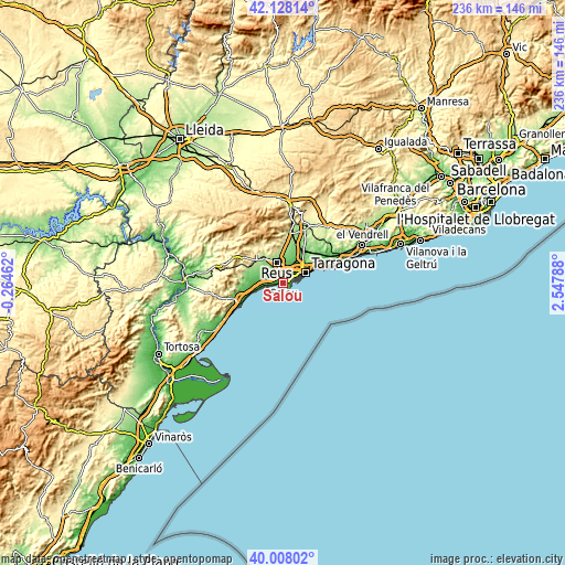
| \ | Map #1 | Map #2 | Topo.Map |
| Scale [m] | -3..66 m | -20..131 m | × |
| Scale [ft] | -10..217 ft | -66..430 ft | × |
| Average | 22.8 m = 75 ft | 42.2 m = 138 ft | × |
| Width | 7.37 km = 4.6 mi | 14.73 km = 9.2 mi | 235.7 km = 146.5 mi |
| Height | 7.37 km = 4.6 mi | 14.73 km = 9.2 mi | 235.7 km = 146.5 mi |
| ↑Max Latitude | 41.109749° | 41.142851° | 42.12814° |
| Latitude at center | 41.07663° | 41.07663° | 41.07663° |
| ↓Min Latitude | 41.043494° | 41.010342° | 40.00802° |
| ← Min Longitude | 1.097685° | 1.053739° | -0.26462° |
| Longitude center | 1.14163° | 1.14163° | 1.14163° |
| →Max Longitude | 1.185575° | 1.229521° | 2.54788° |
Nearby cities:
Cities around Salou sort by population:
• Tarragona elevation 43 m
10.1 km,  63°
63°
• Reus 133 m
9.3 km,  341°
341°
• Cambrils 13 m
6.9 km,  263°
263°
• Vila-seca 40 m
3.9 km,  7°
7°
• La Pineda 10 m
3.6 km,  90°
90°
• La Canonja 42 m
5.9 km,  33°
33°
• Riudoms 117 m
9.9 km,  309°
309°
• Constantí 86 m
10.5 km, 34°
• les Borges del Camp 217 m
14.5 km, 313°
• la Pobla de Mafumet 74 m
13.4 km, 27°
• Almoster 282 m
13.7 km,  349°
349°
• Botarell 198 m
14.4 km,  297°
297°
Multilingual:
 En español:
Salou elevación 6 m.
 En France:
Salou élévation 6 m.


Sources and notes:
- [note 1] Map square and city borders are not equal. Map elevation data is calculated only from area inside that square.
- [src 1] Elevation data from geonames database provided with same terms of usage.
- [src 2] The elevation map of Salou is generated using elevation data from NASA's 3 arcsec (90m) resolution SRTM data.
- [src 3] Base (background) map © OpenStreetMap contributors tiles are generated by Geofabrik and OpenTopoMap.
Copyright & License:
This Salou Elevation Map is licensed under CC BY-SA. You may reuse any part from this page, if you give a proper credit by linking to this URL:
 More info on terms of use page.