Sant Feliu de Llobregat elevation
Sant Feliu de Llobregat (Catalonia, Província de Barcelona), Spain elevation is 48 meters and Sant Feliu de Llobregat elevation in feet is 157 ft above sea level [src 1]. Sant Feliu de Llobregat is a seat of a third-order administrative division (feature code) with elevation that is 555 meters (1821 ft) smaller than average city elevation in Spain.
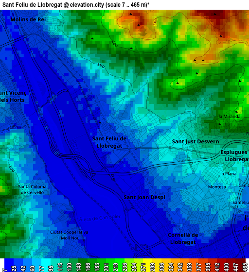
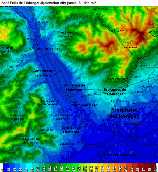
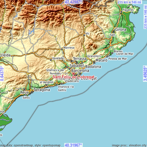
Below is the Elevation map of Sant Feliu de Llobregat, which displays elevation range with different colors. Scale of the first map is from 7 to 465 m (23 to 1526 ft) with average elevation of 91.7 meters (=301 ft) [note 1]
These maps also provides idea of topography and contour of this city, they are displayed at different zoom levels. More info about maps, scale and edge coordinates you can find below images.
| \ | Map #1 | Map #2 | Topo.Map |
| Scale [m] | 7..465 m | -6..511 m | × |
| Scale [ft] | 23..1526 ft | -20..1677 ft | × |
| Average | 91.7 m = 301 ft | 122.2 m = 401 ft | × |
| Width | 7.33 km = 4.6 mi | 14.66 km = 9.1 mi | 234.6 km = 145.8 mi |
| Height | 7.33 km = 4.6 mi | 14.66 km = 9.1 mi | 234.6 km = 145.8 mi |
| ↑Max Latitude | 41.416294° | 41.449241° | 42.42987° |
| Latitude at center | 41.38333° | 41.38333° | 41.38333° |
| ↓Min Latitude | 41.350349° | 41.317352° | 40.31967° |
| ← Min Longitude | 2.006055° | 1.962109° | 0.64375° |
| Longitude center | 2.05° | 2.05° | 2.05° |
| →Max Longitude | 2.093945° | 2.137891° | 3.45625° |
Nearby cities:
Cities around Sant Feliu de Llobregat sort by population:
• L'Hospitalet de Llobregat elevation 18 m
5 km,  122°
122°
• Cornellà de Llobregat 12 m
4.6 km,  143°
143°
• Sant Boi de Llobregat 45 m
4.6 km,  194°
194°
• Esplugues de Llobregat 102 m
3.2 km,  101°
101°
• Sant Joan Despí 22 m
1.9 km,  161°
161°
• Sant Vicenç dels Horts 61 m
3.8 km,  286°
286°
• Molins de Rei 44 m
4.6 km,  323°
323°
• la Maternitat i Sant Ramon 56 m
5.6 km,  92°
92°
• Sant Just Desvern 91 m
1.5 km, 87°
• Pedralbes 130 m
5.1 km,  81°
81°
• Santa Coloma de Cervelló 92 m
3.5 km,  239°
239°
• Vallvidrera, el Tibidabo i les Planes 393 m
5.2 km,  38°
38°
Multilingual:
 En español:
San Feliú de Llobregat elevación 48 m.
 En France:
Sant Feliu de Llobregat élévation 48 m.
 Auf Deutsch:
Sant Feliu de Llobregat höhe über dem Meeresspiegel ist 48 m.

Sources and notes:
- [note 1] Map square and city borders are not equal. Map elevation data is calculated only from area inside that square.
- [src 1] Elevation data from geonames database provided with same terms of usage.
- [src 2] The elevation map of Sant Feliu de Llobregat is generated using elevation data from NASA's 3 arcsec (90m) resolution SRTM data.
- [src 3] Base (background) map © OpenStreetMap contributors tiles are generated by Geofabrik and OpenTopoMap.
Copyright & License:
This Sant Feliu de Llobregat Elevation Map is licensed under CC BY-SA. You may reuse any part from this page, if you give a proper credit by linking to this URL:
 More info on terms of use page.