San Lorenzo de El Escorial elevation
San Lorenzo de El Escorial (Madrid, Provincia de Madrid), Spain elevation is 1049 meters and San Lorenzo de El Escorial elevation in feet is 3442 ft above sea level [src 1]. San Lorenzo de El Escorial is a seat of a third-order administrative division (feature code) with elevation that is 446 meters (1463 ft) bigger than average city elevation in Spain.
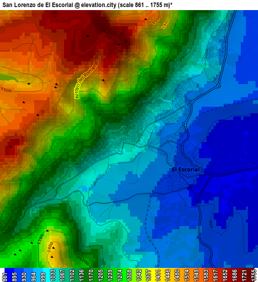
Below is the Elevation map of San Lorenzo de El Escorial, which displays elevation range with different colors. Scale of the first map is from 861 to 1755 m (2825 to 5758 ft) with average elevation of 1169.7 meters (=3838 ft) [note 1]
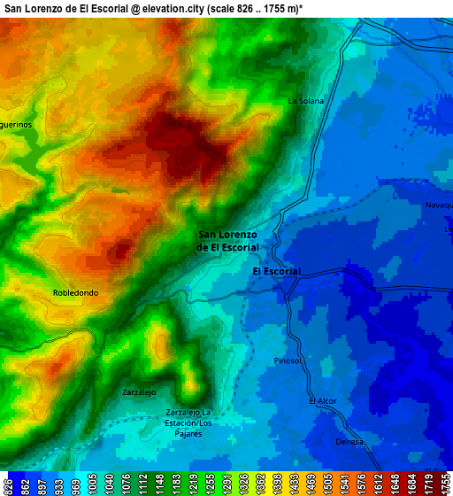
These maps also provides idea of topography and contour of this city, they are displayed at different zoom levels. More info about maps, scale and edge coordinates you can find below images.
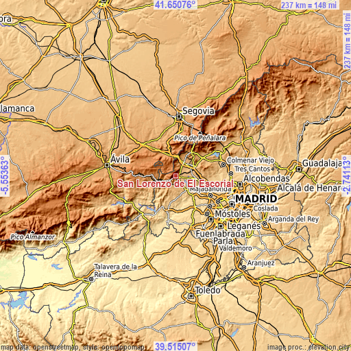
| \ | Map #1 | Map #2 | Topo.Map |
| Scale [m] | 861..1755 m | 826..1755 m | × |
| Scale [ft] | 2825..5758 ft | 2710..5758 ft | × |
| Average | 1169.7 m = 3838 ft | 1139.5 m = 3739 ft | × |
| Width | 7.42 km = 4.6 mi | 14.84 km = 9.2 mi | 237.5 km = 147.6 mi |
| Height | 7.42 km = 4.6 mi | 14.84 km = 9.2 mi | 237.5 km = 147.6 mi |
| ↑Max Latitude | 40.624802° | 40.658148° | 41.65076° |
| Latitude at center | 40.59144° | 40.59144° | 40.59144° |
| ↓Min Latitude | 40.558061° | 40.524665° | 39.51507° |
| ← Min Longitude | -4.191325° | -4.235271° | -5.55363° |
| Longitude center | -4.14738° | -4.14738° | -4.14738° |
| →Max Longitude | -4.103435° | -4.059489° | -2.74113° |
Nearby cities:
Cities around San Lorenzo de El Escorial sort by population:
• Galapagar elevation 883 m
12.2 km,  96°
96°
• El Escorial 917 m
1.9 km,  121°
121°
• Guadarrama 966 m
10.3 km,  28°
28°
• Alpedrete 919 m
12.8 km,  53°
53°
• Valdemorillo 811 m
12.2 km,  146°
146°
• Colmenarejo 871 m
11.5 km,  107°
107°
• Robledo de Chavela 895 m
12.6 km,  216°
216°
• Navalquejigo 889 m
8.4 km,  78°
78°
• Zarzalejo 1110 m
5.6 km,  211°
211°
• Fresnedillas 896 m
11.8 km,  189°
189°
• Santa María de la Alameda 1408 m
9.3 km,  272°
272°
• Peguerinos 1343 m
8.1 km,  298°
298°
Multilingual:
 En español:
El Escorial elevación 1049 m.
 En France:
El Escorial élévation 1049 m.
 Auf Deutsch:
El Escorial höhe über dem Meeresspiegel ist 1049 m.
 На русском:
Сан-Лоренсо-де-Эль-Эскориаль высота над уровнем моря 1049 м
Sources and notes:
- [note 1] Map square and city borders are not equal. Map elevation data is calculated only from area inside that square.
- [src 1] Elevation data from geonames database provided with same terms of usage.
- [src 2] The elevation map of San Lorenzo de El Escorial is generated using elevation data from NASA's 3 arcsec (90m) resolution SRTM data.
- [src 3] Base (background) map © OpenStreetMap contributors tiles are generated by Geofabrik and OpenTopoMap.
Copyright & License:
This San Lorenzo de El Escorial Elevation Map is licensed under CC BY-SA. You may reuse any part from this page, if you give a proper credit by linking to this URL:
 More info on terms of use page.