Santander elevation
Santander (Cantabria, Provincia de Cantabria), Spain elevation is 28 meters and Santander elevation in feet is 92 ft above sea level [src 1]. Santander is a seat of a first-order administrative division (feature code) with elevation that is 575 meters (1886 ft) smaller than average city elevation in Spain.
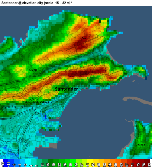
Below is the Elevation map of Santander, which displays elevation range with different colors. Scale of the first map is from -15 to 82 m (-49 to 269 ft) with average elevation of 24 meters (=79 ft) [note 1]
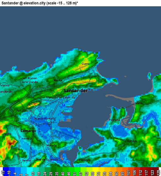
These maps also provides idea of topography and contour of this city, they are displayed at different zoom levels. More info about maps, scale and edge coordinates you can find below images.
| \ | Map #1 | Map #2 | Topo.Map |
| Scale [m] | -15..82 m | -15..128 m | × |
| Scale [ft] | -49..269 ft | -49..420 ft | × |
| Average | 24 m = 79 ft | 23.4 m = 77 ft | × |
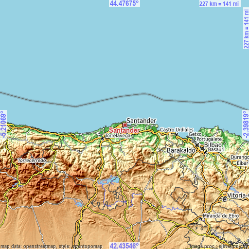
| Width | 7.09 km = 4.4 mi | 14.19 km = 8.8 mi | 227 km = 141.1 mi |
| Height | 7.09 km = 4.4 mi | 14.19 km = 8.8 mi | 227 km = 141.1 mi |
| ↑Max Latitude | 43.496607° | 43.528477° | 44.47675° |
| Latitude at center | 43.46472° | 43.46472° | 43.46472° |
| ↓Min Latitude | 43.432816° | 43.400895° | 42.43546° |
| ← Min Longitude | -3.848385° | -3.892331° | -5.21069° |
| Longitude center | -3.80444° | -3.80444° | -3.80444° |
| →Max Longitude | -3.760495° | -3.716549° | -2.39819° |
Nearby cities:
Cities around Santander sort by population:
• Camargo elevation 32 m
9.1 km,  225°
225°
• El Astillero 33 m
7.2 km,  190°
190°
• Santa Cruz de Bezana 44 m
8.3 km,  253°
253°
• Santa María de Cayón 105 m
17.6 km, 188°
• Miengo 25 m
16.2 km,  255°
255°
• Bareyo 76 m
16.4 km,  89°
89°
• Penagos 134 m
12.5 km,  183°
183°
• San Miguel de Meruelo 11 m
17.4 km, 90°
• Hazas de Cesto 69 m
19 km,  113°
113°
• Arnuero 61 m
19 km, 85°
• Liérganes 95 m
14 km,  160°
160°
• Entrambasaguas 45 m
13.8 km,  133°
133°
Multilingual:
 En español:
Santander elevación 28 m.
 En France:
Santander élévation 28 m.
 Auf Deutsch:
Santander höhe über dem Meeresspiegel ist 28 m.

Sources and notes:
- [note 1] Map square and city borders are not equal. Map elevation data is calculated only from area inside that square.
- [src 1] Elevation data from geonames database provided with same terms of usage.
- [src 2] The elevation map of Santander is generated using elevation data from NASA's 3 arcsec (90m) resolution SRTM data.
- [src 3] Base (background) map © OpenStreetMap contributors tiles are generated by Geofabrik and OpenTopoMap.
Copyright & License:
This Santander Elevation Map is licensed under CC BY-SA. You may reuse any part from this page, if you give a proper credit by linking to this URL:
 More info on terms of use page.