Santibáñez de Tera elevation
Santibáñez de Tera (Castille and León, Provincia de Zamora), Spain elevation is 733 meters and Santibáñez de Tera elevation in feet is 2405 ft above sea level [src 1]. Santibáñez de Tera is a seat of a third-order administrative division (feature code) with elevation that is 130 meters (427 ft) bigger than average city elevation in Spain.
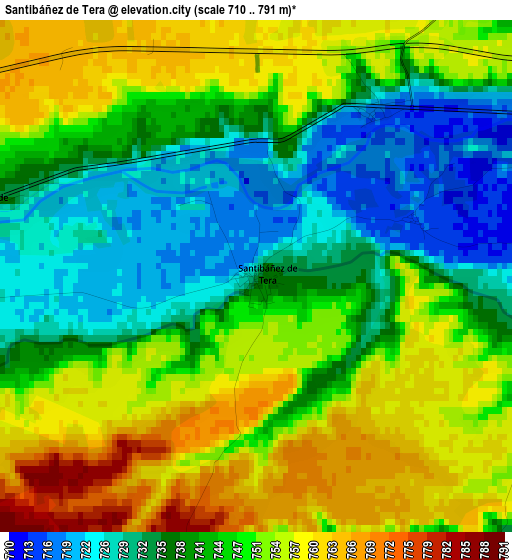
Below is the Elevation map of Santibáñez de Tera, which displays elevation range with different colors. Scale of the first map is from 710 to 791 m (2329 to 2595 ft) with average elevation of 745.1 meters (=2445 ft) [note 1]
These maps also provides idea of topography and contour of this city, they are displayed at different zoom levels. More info about maps, scale and edge coordinates you can find below images.
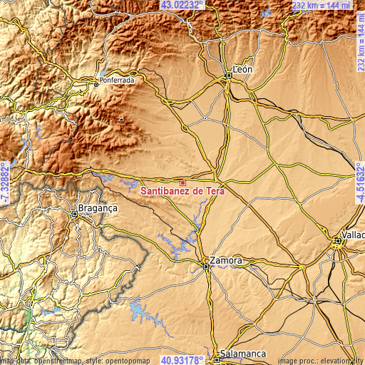
| \ | Map #1 | Topo.Map |
| Scale [m] | 710..791 m | × |
| Scale [ft] | 2329..2595 ft | × |
| Average | 745.1 m = 2445 ft | × |
| Width | 7.26 km = 4.5 mi | 232.4 km = 144.4 mi |
| Height | 7.26 km = 4.5 mi | 232.4 km = 144.4 mi |
| ↑Max Latitude | 42.018287° | 43.02232° |
| Latitude at center | 41.98563° | 41.98563° |
| ↓Min Latitude | 41.952957° | 40.93178° |
| ← Min Longitude | -5.966515° | -7.32882° |
| Longitude center | -5.92257° | -5.92257° |
| →Max Longitude | -5.878625° | -4.51632° |
Nearby cities:
Cities around Santibáñez de Tera sort by population:
• Quiruelas de Vidriales elevation 716 m
8.5 km,  65°
65°
• Micereces de Tera 721 m
4.3 km,  85°
85°
• Melgar de Tera 748 m
7.9 km,  254°
254°
• Santa Croya de Tera 727 m
4.5 km,  266°
266°
• Pueblica de Valverde 730 m
7.7 km,  165°
165°
• Morales de Valverde 732 m
6 km,  155°
155°
• Granucillo 722 m
7.4 km,  356°
356°
• Villanueva de las Peras 744 m
7.4 km,  219°
219°
• Brime de Urz 719 m
7.1 km,  35°
35°
• Quintanilla de Urz 715 m
8.1 km,  49°
49°
• Villaveza de Valverde 711 m
7.6 km,  126°
126°
• Santa María de Valverde 734 m
5.8 km,  190°
190°
Multilingual:
 En español:
Santibáñez de Tera elevación 733 m.
 En France:
Santibáñez de Tera élévation 733 m.
 Auf Deutsch:
Santibáñez de Tera höhe über dem Meeresspiegel ist 733 m.
 На русском:
Santibáñez de Tera высота над уровнем моря 733 м
Sources and notes:
- [note 1] Map square and city borders are not equal. Map elevation data is calculated only from area inside that square.
- [src 1] Elevation data from geonames database provided with same terms of usage.
- [src 2] The elevation map of Santibáñez de Tera is generated using elevation data from NASA's 3 arcsec (90m) resolution SRTM data.
- [src 3] Base (background) map © OpenStreetMap contributors tiles are generated by Geofabrik and OpenTopoMap.
Copyright & License:
This Santibáñez de Tera Elevation Map is licensed under CC BY-SA. You may reuse any part from this page, if you give a proper credit by linking to this URL:
 More info on terms of use page.