Sojuela elevation
Sojuela (La Rioja, Provincia de La Rioja), Spain elevation is 668 meters and Sojuela elevation in feet is 2192 ft above sea level [src 1]. Sojuela is a seat of a third-order administrative division (feature code) with elevation that is 65 meters (213 ft) bigger than average city elevation in Spain.
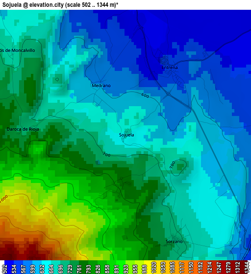
Below is the Elevation map of Sojuela, which displays elevation range with different colors. Scale of the first map is from 502 to 1344 m (1647 to 4409 ft) with average elevation of 703.1 meters (=2307 ft) [note 1]
These maps also provides idea of topography and contour of this city, they are displayed at different zoom levels. More info about maps, scale and edge coordinates you can find below images.
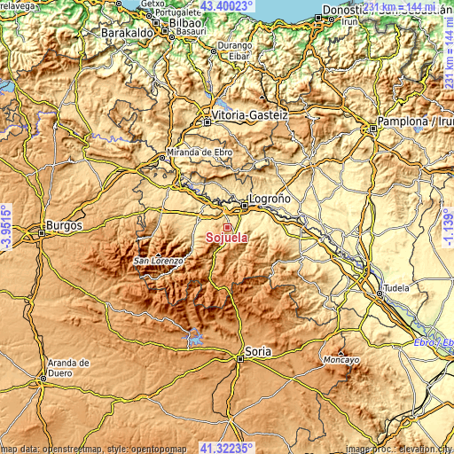
| \ | Map #1 | Topo.Map |
| Scale [m] | 502..1344 m | × |
| Scale [ft] | 1647..4409 ft | × |
| Average | 703.1 m = 2307 ft | × |
| Width | 7.22 km = 4.5 mi | 231 km = 143.5 mi |
| Height | 7.22 km = 4.5 mi | 231 km = 143.5 mi |
| ↑Max Latitude | 42.402339° | 43.40023° |
| Latitude at center | 42.36988° | 42.36988° |
| ↓Min Latitude | 42.337404° | 41.32235° |
| ← Min Longitude | -2.589195° | -3.9515° |
| Longitude center | -2.54525° | -2.54525° |
| →Max Longitude | -2.501305° | -1.139° |
Nearby cities:
Cities around Sojuela sort by population:
• Lardero elevation 438 m
9.3 km,  47°
47°
• Albelda de Iregua 545 m
6.1 km,  102°
102°
• Entrena 554 m
2.3 km,  30°
30°
• Nalda 633 m
6.2 km,  129°
129°
• Viguera 706 m
6.8 km,  171°
171°
• Sorzano 715 m
3.3 km,  155°
155°
• Medrano 597 m
1.7 km,  334°
334°
• Ventosa 647 m
7.7 km,  300°
300°
• Santa Coloma 765 m
9.1 km,  268°
268°
• Hornos de Moncalvillo 677 m
4.1 km,  306°
306°
• Navarrete 502 m
6.9 km,  346°
346°
• Daroca de Rioja 725 m
3 km, 272°
Multilingual:
 En español:
Sojuela elevación 668 m.
 En France:
Sojuela élévation 668 m.


Sources and notes:
- [note 1] Map square and city borders are not equal. Map elevation data is calculated only from area inside that square.
- [src 1] Elevation data from geonames database provided with same terms of usage.
- [src 2] The elevation map of Sojuela is generated using elevation data from NASA's 3 arcsec (90m) resolution SRTM data.
- [src 3] Base (background) map © OpenStreetMap contributors tiles are generated by Geofabrik and OpenTopoMap.
Copyright & License:
This Sojuela Elevation Map is licensed under CC BY-SA. You may reuse any part from this page, if you give a proper credit by linking to this URL:
 More info on terms of use page.