Torremenga elevation
Torremenga (Extremadura, Provincia de Cáceres), Spain elevation is 530 meters and Torremenga elevation in feet is 1739 ft above sea level [src 1]. Torremenga is a seat of a third-order administrative division (feature code) with elevation that is 73 meters (240 ft) smaller than average city elevation in Spain.
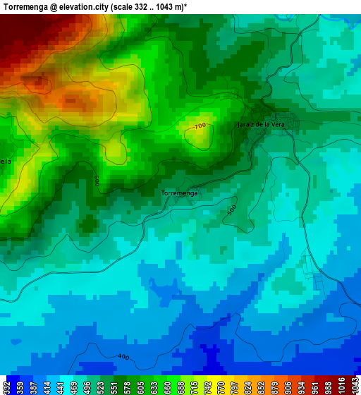
Below is the Elevation map of Torremenga, which displays elevation range with different colors. Scale of the first map is from 332 to 1043 m (1089 to 3422 ft) with average elevation of 539 meters (=1768 ft) [note 1]
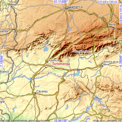
These maps also provides idea of topography and contour of this city, they are displayed at different zoom levels. More info about maps, scale and edge coordinates you can find below images.
| \ | Map #1 | Topo.Map |
| Scale [m] | 332..1043 m | × |
| Scale [ft] | 1089..3422 ft | × |
| Average | 539 m = 1768 ft | × |
| Width | 7.48 km = 4.6 mi | 239.4 km = 148.8 mi |
| Height | 7.48 km = 4.6 mi | 239.4 km = 148.8 mi |
| ↑Max Latitude | 40.080213° | 41.11458° |
| Latitude at center | 40.04658° | 40.04658° |
| ↓Min Latitude | 40.012931° | 38.96158° |
| ← Min Longitude | -5.818655° | -7.18096° |
| Longitude center | -5.77471° | -5.77471° |
| →Max Longitude | -5.730765° | -4.36846° |
Nearby cities:
Cities around Torremenga sort by population:
• Jaraíz de la Vera elevation 549 m
2.3 km,  49°
49°
• Aldeanueva de la Vera 652 m
10.9 km,  34°
34°
• Piornal 1181 m
10 km,  321°
321°
• Majadas 266 m
11.8 km,  167°
167°
• Garganta la Olla 581 m
7.1 km,  358°
358°
• Tejeda de Tiétar 439 m
8.7 km,  248°
248°
• Casas del Castañar 680 m
13 km,  301°
301°
• Arroyomolinos de la Vera 594 m
6.5 km,  276°
276°
• Barrado 807 m
10 km, 295°
• Cabrero 730 m
12.5 km,  306°
306°
• Gargüera 524 m
13.1 km, 277°
• Collado 453 m
4.8 km,  75°
75°
Multilingual:
 En español:
Torremenga elevación 530 m.
 En France:
Torremenga élévation 530 m.
 Auf Deutsch:
Torremenga höhe über dem Meeresspiegel ist 530 m.

Sources and notes:
- [note 1] Map square and city borders are not equal. Map elevation data is calculated only from area inside that square.
- [src 1] Elevation data from geonames database provided with same terms of usage.
- [src 2] The elevation map of Torremenga is generated using elevation data from NASA's 3 arcsec (90m) resolution SRTM data.
- [src 3] Base (background) map © OpenStreetMap contributors tiles are generated by Geofabrik and OpenTopoMap.
Copyright & License:
This Torremenga Elevation Map is licensed under CC BY-SA. You may reuse any part from this page, if you give a proper credit by linking to this URL:
 More info on terms of use page.