Uña elevation
Uña (Castille-La Mancha, Provincia de Cuenca), Spain elevation is 1140 meters and Uña elevation in feet is 3740 ft above sea level [src 1]. Uña is a seat of a third-order administrative division (feature code) with elevation that is 537 meters (1762 ft) bigger than average city elevation in Spain.
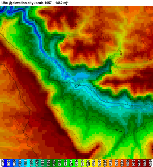
Below is the Elevation map of Uña, which displays elevation range with different colors. Scale of the first map is from 1057 to 1462 m (3468 to 4797 ft) with average elevation of 1309.3 meters (=4296 ft) [note 1]
These maps also provides idea of topography and contour of this city, they are displayed at different zoom levels. More info about maps, scale and edge coordinates you can find below images.
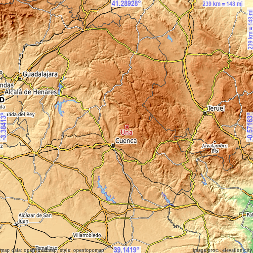
| \ | Map #1 | Topo.Map |
| Scale [m] | 1057..1462 m | × |
| Scale [ft] | 3468..4797 ft | × |
| Average | 1309.3 m = 4296 ft | × |
| Width | 7.46 km = 4.6 mi | 238.8 km = 148.4 mi |
| Height | 7.46 km = 4.6 mi | 238.8 km = 148.4 mi |
| ↑Max Latitude | 40.257645° | 41.28928° |
| Latitude at center | 40.2241° | 40.2241° |
| ↓Min Latitude | 40.190538° | 39.1419° |
| ← Min Longitude | -2.021825° | -3.38413° |
| Longitude center | -1.97788° | -1.97788° |
| →Max Longitude | -1.933935° | -0.57163° |
Nearby cities:
Cities around Uña sort by population:
• Cuenca elevation 941 m
21.9 km,  217°
217°
• Villalba de la Sierra 987 m
9.5 km,  276°
276°
• Mariana 968 m
15.6 km,  246°
246°
• Zarzuela 1136 m
11.9 km,  289°
289°
• Valdemoro-Sierra 1111 m
22.6 km,  127°
127°
• Huélamo 1316 m
15.4 km,  67°
67°
• Arcos de la Sierra 1011 m
17.8 km,  319°
319°
• Portilla 1070 m
11.4 km,  309°
309°
• Valdemeca 1312 m
19.9 km,  90°
90°
• Beamud 1341 m
13.3 km,  108°
108°
• Castillejo-Sierra 1000 m
21.7 km, 320°
• Bascuñana de San Pedro 1058 m
21.3 km,  266°
266°
Multilingual:
 En español:
Uña elevación 1140 m.
 En France:
Uña élévation 1140 m.


Sources and notes:
- [note 1] Map square and city borders are not equal. Map elevation data is calculated only from area inside that square.
- [src 1] Elevation data from geonames database provided with same terms of usage.
- [src 2] The elevation map of Uña is generated using elevation data from NASA's 3 arcsec (90m) resolution SRTM data.
- [src 3] Base (background) map © OpenStreetMap contributors tiles are generated by Geofabrik and OpenTopoMap.
Copyright & License:
This Uña Elevation Map is licensed under CC BY-SA. You may reuse any part from this page, if you give a proper credit by linking to this URL:
 More info on terms of use page.