Used elevation
Used (Aragon, Provincia de Zaragoza), Spain elevation is 1049 meters and Used elevation in feet is 3442 ft above sea level [src 1]. Used is a seat of a third-order administrative division (feature code) with elevation that is 446 meters (1463 ft) bigger than average city elevation in Spain.
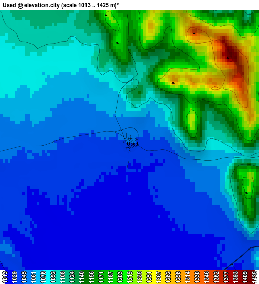
Below is the Elevation map of Used, which displays elevation range with different colors. Scale of the first map is from 1013 to 1425 m (3323 to 4675 ft) with average elevation of 1091.5 meters (=3581 ft) [note 1]
These maps also provides idea of topography and contour of this city, they are displayed at different zoom levels. More info about maps, scale and edge coordinates you can find below images.
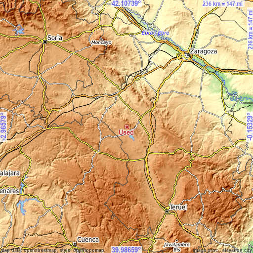
| \ | Map #1 | Topo.Map |
| Scale [m] | 1013..1425 m | × |
| Scale [ft] | 3323..4675 ft | × |
| Average | 1091.5 m = 3581 ft | × |
| Width | 7.37 km = 4.6 mi | 235.8 km = 146.5 mi |
| Height | 7.37 km = 4.6 mi | 235.8 km = 146.5 mi |
| ↑Max Latitude | 41.08867° | 42.10739° |
| Latitude at center | 41.05554° | 41.05554° |
| ↓Min Latitude | 41.022394° | 39.98659° |
| ← Min Longitude | -1.603485° | -2.96579° |
| Longitude center | -1.55954° | -1.55954° |
| →Max Longitude | -1.515595° | -0.15329° |
Nearby cities:
Cities around Used sort by population:
• Cubel elevation 1113 m
7.9 km,  304°
304°
• Atea 839 m
11.7 km,  1°
1°
• Gallocanta 1017 m
7.9 km,  146°
146°
• Manchones 726 m
13.1 km,  36°
36°
• Castejón de Tornos 1081 m
12.8 km,  120°
120°
• Torralba de los Frailes 1093 m
8.7 km,  255°
255°
• Val de San Martín 1009 m
9.2 km,  88°
88°
• Santed 1064 m
4.9 km, 122°
• Valdehorna 885 m
11.5 km,  80°
80°
• Orcajo 927 m
8.4 km, 44°
• Aldehuela de Liestos 997 m
11.9 km,  274°
274°
• Balconchán 885 m
9.1 km,  67°
67°
Multilingual:
 En español:
Used elevación 1049 m.
 En France:
Used élévation 1049 m.


Sources and notes:
- [note 1] Map square and city borders are not equal. Map elevation data is calculated only from area inside that square.
- [src 1] Elevation data from geonames database provided with same terms of usage.
- [src 2] The elevation map of Used is generated using elevation data from NASA's 3 arcsec (90m) resolution SRTM data.
- [src 3] Base (background) map © OpenStreetMap contributors tiles are generated by Geofabrik and OpenTopoMap.
Copyright & License:
This Used Elevation Map is licensed under CC BY-SA. You may reuse any part from this page, if you give a proper credit by linking to this URL:
 More info on terms of use page.