Valdescorriel elevation
Valdescorriel (Castille and León, Provincia de Zamora), Spain elevation is 736 meters and Valdescorriel elevation in feet is 2415 ft above sea level [src 1]. Valdescorriel is a seat of a third-order administrative division (feature code) with elevation that is 133 meters (436 ft) bigger than average city elevation in Spain.
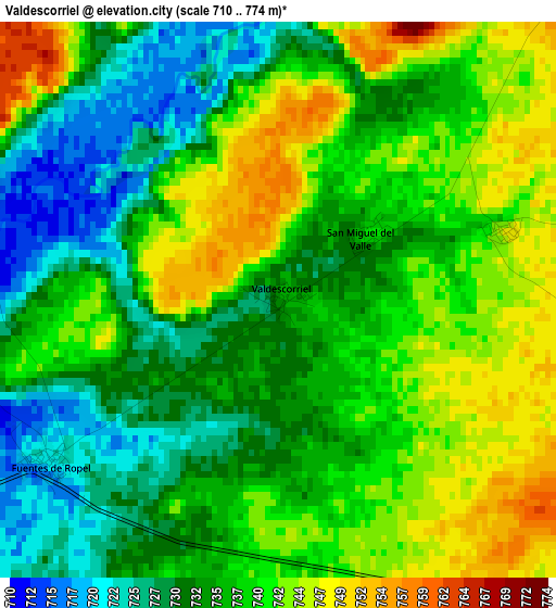
Below is the Elevation map of Valdescorriel, which displays elevation range with different colors. Scale of the first map is from 710 to 774 m (2329 to 2539 ft) with average elevation of 736.7 meters (=2417 ft) [note 1]
These maps also provides idea of topography and contour of this city, they are displayed at different zoom levels. More info about maps, scale and edge coordinates you can find below images.
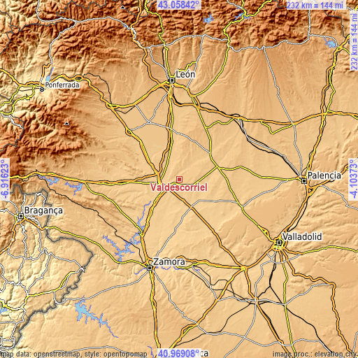
| \ | Map #1 | Topo.Map |
| Scale [m] | 710..774 m | × |
| Scale [ft] | 2329..2539 ft | × |
| Average | 736.7 m = 2417 ft | × |
| Width | 7.26 km = 4.5 mi | 232.3 km = 144.3 mi |
| Height | 7.26 km = 4.5 mi | 232.3 km = 144.3 mi |
| ↑Max Latitude | 42.054968° | 43.05842° |
| Latitude at center | 42.02233° | 42.02233° |
| ↓Min Latitude | 41.989675° | 40.96908° |
| ← Min Longitude | -5.553925° | -6.91623° |
| Longitude center | -5.50998° | -5.50998° |
| →Max Longitude | -5.466035° | -4.10373° |
Nearby cities:
Cities around Valdescorriel sort by population:
• Valderas elevation 755 m
8.3 km,  41°
41°
• San Cristóbal de Entreviñas 716 m
10.6 km,  284°
284°
• Villanueva del Campo 754 m
9.5 km,  115°
115°
• Cimanes de la Vega 720 m
12.8 km,  325°
325°
• Fuentes de Ropel 722 m
3.6 km,  234°
234°
• Castrogonzalo 724 m
8.4 km,  245°
245°
• Villalobos 726 m
9 km,  161°
161°
• San Esteban del Molar 732 m
10.1 km,  199°
199°
• Campazas 775 m
13.4 km,  5°
5°
• Vega de Villalobos 735 m
6.9 km,  146°
146°
• Quintanilla del Molar 747 m
6.2 km,  126°
126°
• Prado 714 m
13.5 km, 146°
Multilingual:
 En español:
Valdescorriel elevación 736 m.
 En France:
Valdescorriel élévation 736 m.
 Auf Deutsch:
Valdescorriel höhe über dem Meeresspiegel ist 736 m.

Sources and notes:
- [note 1] Map square and city borders are not equal. Map elevation data is calculated only from area inside that square.
- [src 1] Elevation data from geonames database provided with same terms of usage.
- [src 2] The elevation map of Valdescorriel is generated using elevation data from NASA's 3 arcsec (90m) resolution SRTM data.
- [src 3] Base (background) map © OpenStreetMap contributors tiles are generated by Geofabrik and OpenTopoMap.
Copyright & License:
This Valdescorriel Elevation Map is licensed under CC BY-SA. You may reuse any part from this page, if you give a proper credit by linking to this URL:
 More info on terms of use page.