Vallfogona de Balaguer elevation
Vallfogona de Balaguer (Catalonia, Província de Lleida), Spain elevation is 236 meters and Vallfogona de Balaguer elevation in feet is 774 ft above sea level [src 1]. Vallfogona de Balaguer is a populated place (feature code) with elevation that is 367 meters (1204 ft) smaller than average city elevation in Spain.
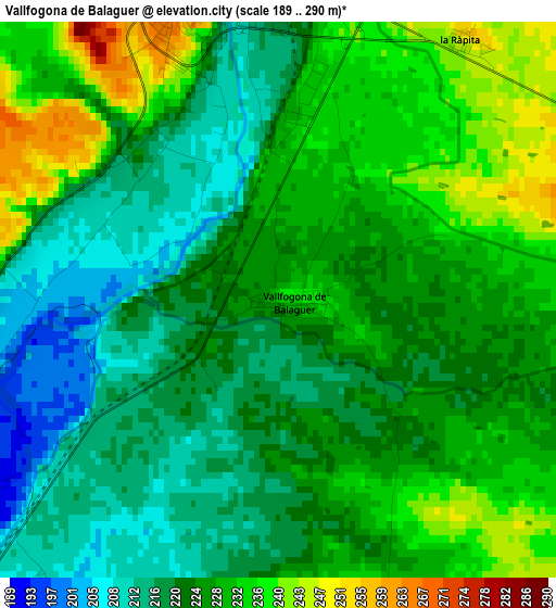
Below is the Elevation map of Vallfogona de Balaguer, which displays elevation range with different colors. Scale of the first map is from 189 to 290 m (620 to 951 ft) with average elevation of 225.1 meters (=739 ft) [note 1]
These maps also provides idea of topography and contour of this city, they are displayed at different zoom levels. More info about maps, scale and edge coordinates you can find below images.
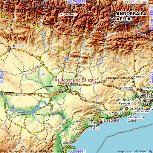
| \ | Map #1 | Topo.Map |
| Scale [m] | 189..290 m | × |
| Scale [ft] | 620..951 ft | × |
| Average | 225.1 m = 739 ft | × |
| Width | 7.29 km = 4.5 mi | 233.3 km = 145 mi |
| Height | 7.29 km = 4.5 mi | 233.3 km = 145 mi |
| ↑Max Latitude | 41.784886° | 42.79263° |
| Latitude at center | 41.75211° | 41.75211° |
| ↓Min Latitude | 41.719317° | 40.69444° |
| ← Min Longitude | 0.769905° | -0.5924° |
| Longitude center | 0.81385° | 0.81385° |
| →Max Longitude | 0.857795° | 2.2201° |
Nearby cities:
Cities around Vallfogona de Balaguer sort by population:
• Balaguer elevation 223 m
4.3 km,  356°
356°
• Linyola 229 m
10.3 km,  124°
124°
• Bellvís 208 m
8.8 km,  177°
177°
• Albesa 243 m
12.8 km,  270°
270°
• Térmens 211 m
5.6 km,  224°
224°
• Bellcaire d'Urgell 251 m
8.5 km,  91°
91°
• Corbins 176 m
12.2 km,  231°
231°
• Camarasa 294 m
14.7 km,  21°
21°
• Sidamon 221 m
13.3 km,  173°
173°
• Penelles 262 m
12.7 km, 91°
• Castelló de Farfanya 337 m
9.8 km,  317°
317°
• el Poal 211 m
8.8 km,  150°
150°
Multilingual:
 En español:
Vallfogona de Balaguer elevación 236 m.
 En France:
Vallfogona de Balaguer élévation 236 m.
 Auf Deutsch:
Vallfogona de Balaguer höhe über dem Meeresspiegel ist 236 m.
 На русском:
Vallfogona de Balaguer высота над уровнем моря 236 м
Sources and notes:
- [note 1] Map square and city borders are not equal. Map elevation data is calculated only from area inside that square.
- [src 1] Elevation data from geonames database provided with same terms of usage.
- [src 2] The elevation map of Vallfogona de Balaguer is generated using elevation data from NASA's 3 arcsec (90m) resolution SRTM data.
- [src 3] Base (background) map © OpenStreetMap contributors tiles are generated by Geofabrik and OpenTopoMap.
Copyright & License:
This Vallfogona de Balaguer Elevation Map is licensed under CC BY-SA. You may reuse any part from this page, if you give a proper credit by linking to this URL:
 More info on terms of use page.