Villamediana elevation
Villamediana (Castille and León, Provincia de Palencia), Spain elevation is 787 meters and Villamediana elevation in feet is 2582 ft above sea level [src 1]. Villamediana is a seat of a third-order administrative division (feature code) with elevation that is 184 meters (604 ft) bigger than average city elevation in Spain.
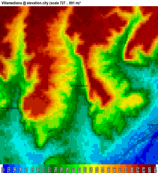
Below is the Elevation map of Villamediana, which displays elevation range with different colors. Scale of the first map is from 727 to 891 m (2385 to 2923 ft) with average elevation of 814.9 meters (=2674 ft) [note 1]
These maps also provides idea of topography and contour of this city, they are displayed at different zoom levels. More info about maps, scale and edge coordinates you can find below images.
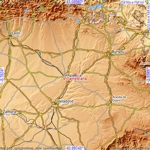
| \ | Map #1 | Topo.Map |
| Scale [m] | 727..891 m | × |
| Scale [ft] | 2385..2923 ft | × |
| Average | 814.9 m = 2674 ft | × |
| Width | 7.26 km = 4.5 mi | 232.2 km = 144.3 mi |
| Height | 7.26 km = 4.5 mi | 232.2 km = 144.3 mi |
| ↑Max Latitude | 42.082864° | 43.08587° |
| Latitude at center | 42.05024° | 42.05024° |
| ↓Min Latitude | 42.0176° | 40.99745° |
| ← Min Longitude | -4.405095° | -5.7674° |
| Longitude center | -4.36115° | -4.36115° |
| →Max Longitude | -4.317205° | -2.9549° |
Nearby cities:
Cities around Villamediana sort by population:
• Torquemada elevation 747 m
3.9 km,  115°
115°
• Villalobón 755 m
12 km,  259°
259°
• Monzón de Campos 755 m
13.1 km,  303°
303°
• Villaviudas 764 m
9.9 km,  170°
170°
• Quintana del Puente 753 m
13.3 km,  73°
73°
• Fuentes de Valdepero 799 m
11.8 km,  283°
283°
• Soto de Cerrato 727 m
12.2 km,  207°
207°
• Herrera de Valdecañas 777 m
13.3 km,  90°
90°
• Hornillos de Cerrato 790 m
10.1 km,  133°
133°
• Cordovilla la Real 745 m
9 km, 68°
• Valdeolmillos 784 m
3.4 km,  252°
252°
• Reinoso de Cerrato 741 m
8.4 km,  192°
192°
Multilingual:
 En español:
Villamediana elevación 787 m.
 En France:
Villamediana élévation 787 m.
 Auf Deutsch:
Villamediana höhe über dem Meeresspiegel ist 787 m.

Sources and notes:
- [note 1] Map square and city borders are not equal. Map elevation data is calculated only from area inside that square.
- [src 1] Elevation data from geonames database provided with same terms of usage.
- [src 2] The elevation map of Villamediana is generated using elevation data from NASA's 3 arcsec (90m) resolution SRTM data.
- [src 3] Base (background) map © OpenStreetMap contributors tiles are generated by Geofabrik and OpenTopoMap.
Copyright & License:
This Villamediana Elevation Map is licensed under CC BY-SA. You may reuse any part from this page, if you give a proper credit by linking to this URL:
 More info on terms of use page.