Villaviudas elevation
Villaviudas (Castille and León, Provincia de Palencia), Spain elevation is 764 meters and Villaviudas elevation in feet is 2507 ft above sea level [src 1]. Villaviudas is a seat of a third-order administrative division (feature code) with elevation that is 161 meters (528 ft) bigger than average city elevation in Spain.
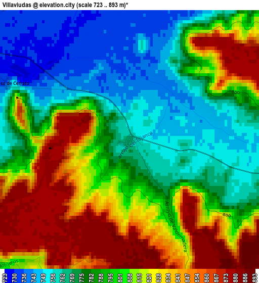
Below is the Elevation map of Villaviudas, which displays elevation range with different colors. Scale of the first map is from 723 to 893 m (2372 to 2930 ft) with average elevation of 797.7 meters (=2617 ft) [note 1]
These maps also provides idea of topography and contour of this city, they are displayed at different zoom levels. More info about maps, scale and edge coordinates you can find below images.
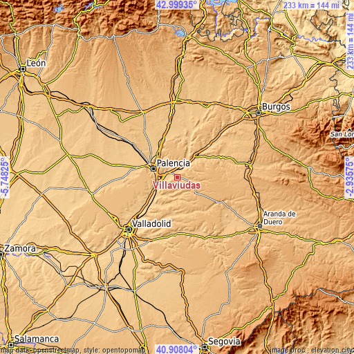
| \ | Map #1 | Topo.Map |
| Scale [m] | 723..893 m | × |
| Scale [ft] | 2372..2930 ft | × |
| Average | 797.7 m = 2617 ft | × |
| Width | 7.27 km = 4.5 mi | 232.5 km = 144.5 mi |
| Height | 7.27 km = 4.5 mi | 232.5 km = 144.5 mi |
| ↑Max Latitude | 41.994939° | 42.99935° |
| Latitude at center | 41.96227° | 41.96227° |
| ↓Min Latitude | 41.929585° | 40.90804° |
| ← Min Longitude | -4.385945° | -5.74825° |
| Longitude center | -4.342° | -4.342° |
| →Max Longitude | -4.298055° | -2.93575° |
Nearby cities:
Cities around Villaviudas sort by population:
• Venta de Baños elevation 724 m
13.1 km,  249°
249°
• Baltanás 783 m
8.4 km,  109°
109°
• Torquemada 747 m
8.3 km,  13°
13°
• Cevico de la Torre 749 m
13.6 km,  204°
204°
• Villamediana 787 m
9.9 km,  350°
350°
• Soto de Cerrato 727 m
7.3 km,  262°
262°
• Castrillo de Onielo 827 m
12.1 km,  163°
163°
• Hornillos de Cerrato 790 m
6.4 km,  63°
63°
• Valle de Cerrato 814 m
9.3 km,  190°
190°
• Hontoria de Cerrato 747 m
10.1 km,  235°
235°
• Valdeolmillos 784 m
10 km,  331°
331°
• Reinoso de Cerrato 741 m
3.8 km,  294°
294°
Multilingual:
 En español:
Villaviudas elevación 764 m.
 En France:
Villaviudas élévation 764 m.
 Auf Deutsch:
Villaviudas höhe über dem Meeresspiegel ist 764 m.

Sources and notes:
- [note 1] Map square and city borders are not equal. Map elevation data is calculated only from area inside that square.
- [src 1] Elevation data from geonames database provided with same terms of usage.
- [src 2] The elevation map of Villaviudas is generated using elevation data from NASA's 3 arcsec (90m) resolution SRTM data.
- [src 3] Base (background) map © OpenStreetMap contributors tiles are generated by Geofabrik and OpenTopoMap.
Copyright & License:
This Villaviudas Elevation Map is licensed under CC BY-SA. You may reuse any part from this page, if you give a proper credit by linking to this URL:
 More info on terms of use page.