Villangómez elevation
Villangómez (Castille and León, Provincia de Burgos), Spain elevation is 848 meters and Villangómez elevation in feet is 2782 ft above sea level [src 1]. Villangómez is a seat of a third-order administrative division (feature code) with elevation that is 245 meters (804 ft) bigger than average city elevation in Spain.
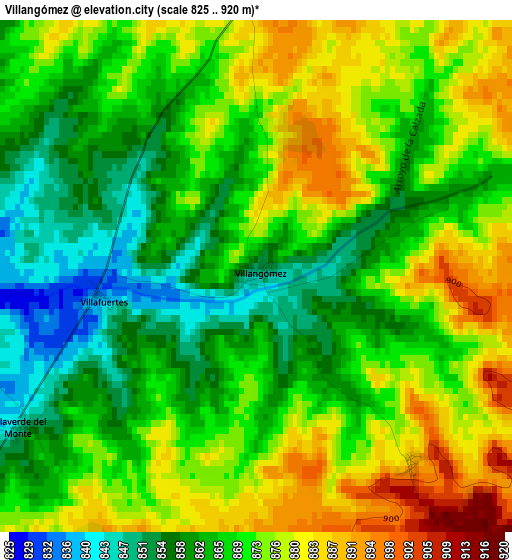
Below is the Elevation map of Villangómez, which displays elevation range with different colors. Scale of the first map is from 825 to 920 m (2707 to 3018 ft) with average elevation of 869.4 meters (=2852 ft) [note 1]
These maps also provides idea of topography and contour of this city, they are displayed at different zoom levels. More info about maps, scale and edge coordinates you can find below images.
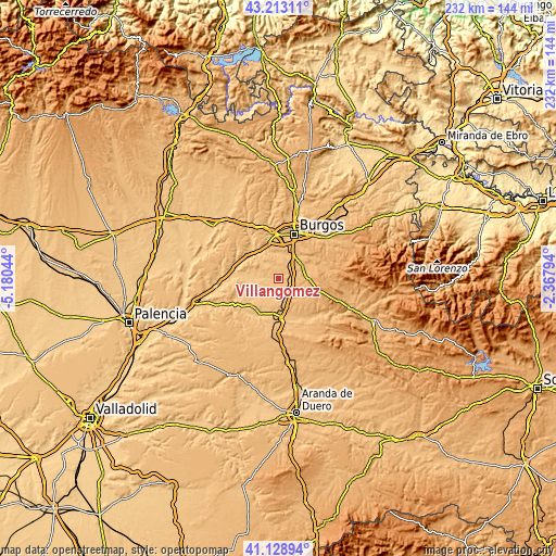
| \ | Map #1 | Topo.Map |
| Scale [m] | 825..920 m | × |
| Scale [ft] | 2707..3018 ft | × |
| Average | 869.4 m = 2852 ft | × |
| Width | 7.24 km = 4.5 mi | 231.7 km = 144 mi |
| Height | 7.24 km = 4.5 mi | 231.7 km = 144 mi |
| ↑Max Latitude | 42.212167° | 43.21311° |
| Latitude at center | 42.17961° | 42.17961° |
| ↓Min Latitude | 42.147036° | 41.12894° |
| ← Min Longitude | -3.818135° | -5.18044° |
| Longitude center | -3.77419° | -3.77419° |
| →Max Longitude | -3.730245° | -2.36794° |
Nearby cities:
Cities around Villangómez sort by population:
• Villariezo elevation 860 m
10.6 km,  18°
18°
• Cogollos 885 m
6.5 km,  69°
69°
• Presencio 814 m
10.5 km,  274°
274°
• Madrigal del Monte 939 m
9 km,  115°
115°
• Villamayor de los Montes 888 m
8.3 km,  174°
174°
• Madrigalejo del Monte 896 m
7.4 km,  146°
146°
• Valdorros 901 m
5.4 km,  98°
98°
• Villaverde del Monte 849 m
3.9 km,  237°
237°
• Hontoria de la Cantera 945 m
10.9 km,  84°
84°
• Saldaña de Burgos 866 m
10.8 km,  35°
35°
• Zael 842 m
9.3 km,  207°
207°
• Arcos 838 m
9.8 km,  9°
9°
Multilingual:
 En español:
Villangómez elevación 848 m.
 En France:
Villangómez élévation 848 m.
 Auf Deutsch:
Villangómez höhe über dem Meeresspiegel ist 848 m.

Sources and notes:
- [note 1] Map square and city borders are not equal. Map elevation data is calculated only from area inside that square.
- [src 1] Elevation data from geonames database provided with same terms of usage.
- [src 2] The elevation map of Villangómez is generated using elevation data from NASA's 3 arcsec (90m) resolution SRTM data.
- [src 3] Base (background) map © OpenStreetMap contributors tiles are generated by Geofabrik and OpenTopoMap.
Copyright & License:
This Villangómez Elevation Map is licensed under CC BY-SA. You may reuse any part from this page, if you give a proper credit by linking to this URL:
 More info on terms of use page.