Alfarnatejo elevation
Alfarnatejo (Andalusia, Provincia de Málaga), Spain elevation is 900 meters and Alfarnatejo elevation in feet is 2953 ft above sea level [src 1]. Alfarnatejo is a seat of a third-order administrative division (feature code) with elevation that is 297 meters (974 ft) bigger than average city elevation in Spain.
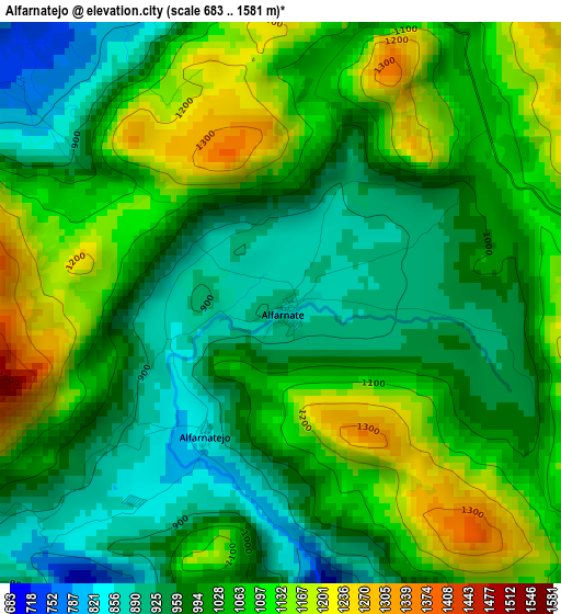
Below is the Elevation map of Alfarnatejo, which displays elevation range with different colors. Scale of the first map is from 683 to 1581 m (2241 to 5187 ft) with average elevation of 1029.7 meters (=3378 ft) [note 1]
These maps also provides idea of topography and contour of this city, they are displayed at different zoom levels. More info about maps, scale and edge coordinates you can find below images.
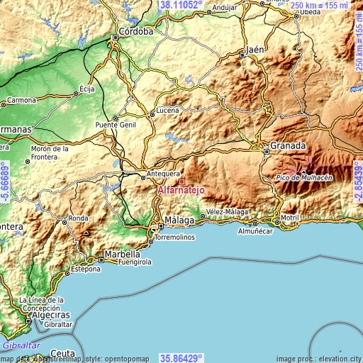
| \ | Map #1 | Topo.Map |
| Scale [m] | 683..1581 m | × |
| Scale [ft] | 2241..5187 ft | × |
| Average | 1029.7 m = 3378 ft | × |
| Width | 7.81 km = 4.9 mi | 249.8 km = 155.2 mi |
| Height | 7.81 km = 4.9 mi | 249.8 km = 155.2 mi |
| ↑Max Latitude | 37.03079° | 38.11052° |
| Latitude at center | 36.9957° | 36.9957° |
| ↓Min Latitude | 36.960594° | 35.86429° |
| ← Min Longitude | -4.304585° | -5.66689° |
| Longitude center | -4.26064° | -4.26064° |
| →Max Longitude | -4.216695° | -2.85439° |
Nearby cities:
Cities around Alfarnatejo sort by population:
• Archidona elevation 730 m
16 km,  314°
314°
• Villanueva del Trabuco 686 m
7.8 km,  297°
297°
• Periana 569 m
9.6 km,  140°
140°
• Villanueva del Rosario 693 m
9.3 km,  270°
270°
• Colmenar 673 m
12.1 km,  213°
213°
• Ríogordo 414 m
9.2 km,  198°
198°
• Zafarraya 893 m
10.6 km,  102°
102°
• Alcaucín 513 m
16.6 km,  128°
128°
• Viñuela 166 m
18.2 km, 144°
• Comares 700 m
16.3 km,  175°
175°
• Alfarnate 885 m
0.2 km, 143°
• Cútar 296 m
18.5 km,  170°
170°
Multilingual:
 En español:
Alfarnatejo elevación 900 m.
 En France:
Alfarnatejo élévation 900 m.
 Auf Deutsch:
Alfarnatejo höhe über dem Meeresspiegel ist 900 m.

Sources and notes:
- [note 1] Map square and city borders are not equal. Map elevation data is calculated only from area inside that square.
- [src 1] Elevation data from geonames database provided with same terms of usage.
- [src 2] The elevation map of Alfarnatejo is generated using elevation data from NASA's 3 arcsec (90m) resolution SRTM data.
- [src 3] Base (background) map © OpenStreetMap contributors tiles are generated by Geofabrik and OpenTopoMap.
Copyright & License:
This Alfarnatejo Elevation Map is licensed under CC BY-SA. You may reuse any part from this page, if you give a proper credit by linking to this URL:
 More info on terms of use page.