Ríogordo elevation
Ríogordo (Andalusia, Provincia de Málaga), Spain elevation is 414 meters and Ríogordo elevation in feet is 1358 ft above sea level [src 1]. Ríogordo is a populated place (feature code) with elevation that is 189 meters (620 ft) smaller than average city elevation in Spain.
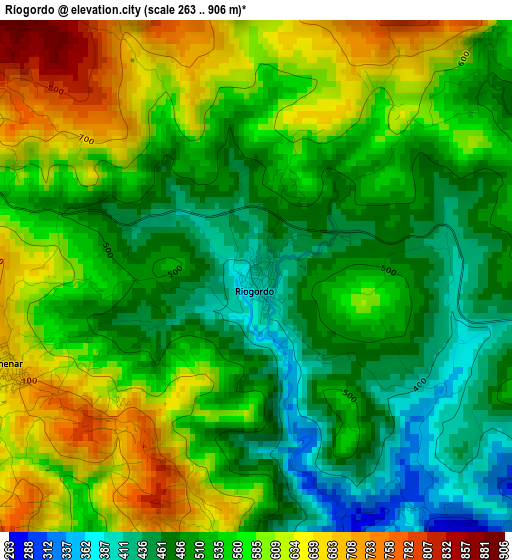
Below is the Elevation map of Ríogordo, which displays elevation range with different colors. Scale of the first map is from 263 to 906 m (863 to 2972 ft) with average elevation of 544.7 meters (=1787 ft) [note 1]
These maps also provides idea of topography and contour of this city, they are displayed at different zoom levels. More info about maps, scale and edge coordinates you can find below images.
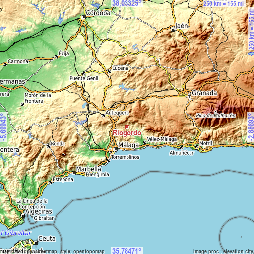
| \ | Map #1 | Topo.Map |
| Scale [m] | 263..906 m | × |
| Scale [ft] | 863..2972 ft | × |
| Average | 544.7 m = 1787 ft | × |
| Width | 7.81 km = 4.9 mi | 250 km = 155.3 mi |
| Height | 7.81 km = 4.9 mi | 250 km = 155.3 mi |
| ↑Max Latitude | 36.952396° | 38.03325° |
| Latitude at center | 36.91727° | 36.91727° |
| ↓Min Latitude | 36.882127° | 35.78471° |
| ← Min Longitude | -4.337125° | -5.69943° |
| Longitude center | -4.29318° | -4.29318° |
| →Max Longitude | -4.249235° | -2.88693° |
Nearby cities:
Cities around Ríogordo sort by population:
• Villanueva del Trabuco elevation 686 m
13 km,  341°
341°
• Periana 569 m
9.1 km,  81°
81°
• Villanueva del Rosario 693 m
10.9 km,  324°
324°
• Casabermeja 568 m
12.4 km,  257°
257°
• Colmenar 673 m
4 km,  250°
250°
• Zafarraya 893 m
14.7 km,  63°
63°
• Almáchar 222 m
13.9 km,  150°
150°
• Benamargosa 109 m
12.7 km,  135°
135°
• Comares 700 m
8.6 km, 151°
• Alfarnate 885 m
9.1 km,  19°
19°
• Cútar 296 m
11.2 km, 148°
• Alfarnatejo 900 m
9.2 km, 18°
Multilingual:
 En español:
Ríogordo elevación 414 m.
 En France:
Ríogordo élévation 414 m.
 Auf Deutsch:
Ríogordo höhe über dem Meeresspiegel ist 414 m.

Sources and notes:
- [note 1] Map square and city borders are not equal. Map elevation data is calculated only from area inside that square.
- [src 1] Elevation data from geonames database provided with same terms of usage.
- [src 2] The elevation map of Ríogordo is generated using elevation data from NASA's 3 arcsec (90m) resolution SRTM data.
- [src 3] Base (background) map © OpenStreetMap contributors tiles are generated by Geofabrik and OpenTopoMap.
Copyright & License:
This Ríogordo Elevation Map is licensed under CC BY-SA. You may reuse any part from this page, if you give a proper credit by linking to this URL:
 More info on terms of use page.